Cornwall geodata
Cornwall (Prince Edward Island) is a populated place; located in Canada in America/Halifax (GMT-3) time zone. With population of 2,272 people, there are 704 cities with bigger population in this country. Compared to other cities in Canada, 58.8% of cities are located further ↑North; 95.5% of cities are located further ←West and 90% of cities have higher elevation than Cornwall. Note1


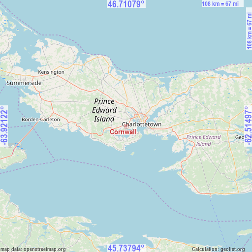
Cornwall GPS coordinates[2]
46° 13' 35.472" North, 63° 13' 5.124" West
| Map corner | latitude | longitude |
|---|---|---|
| Upper-left | 46.71079°, | -63.92122° |
| Center: | 46.22652°, | -63.21809° |
| Lower-right: | 45.73794°, | -62.51497° |
| Map W x H: | 108.2×108.2 km | = 67.2×67.2mi |
| max Lat: | 73.03752° ⇑58.8% North |
| Cornwall: | 46.22652° |
| min Lat: | ⇓41.2% South 42.05009° |
| min Long | Cornwall | max Long |
| -139.43328° | -63.21809° | -52.70931° |
| W 95.5%⇐ | ⇒4.5% E |
Elevation
Elevation of Cornwall is 15 m = 49 ft, and this is 239.4 m = 785 ft below average elevation for this country.
| Max E: |
1518 m = 4980 ft | 90% |
| Avg. | 254.4 m = 835 ft | |
| Cornwall | 15 m = 49 ft | |
Min E: |
-2 m = -7 ft | 10% |
See also: Canada elevation on elevation.city.
Geographical zone
Cornwall is located in North temperate zone (between Tropic of Cancer and the Arctic Circle). Distance of this North polar circle is 2261.3 km =1405.1 mi to North.| Distance of | km | miles | from Cornwall |
|---|---|---|---|
| North Pole | 4867.2 | 3024.3 | to North |
| Arctic Circle | 2261.3 | 1405.1 | to North |
| Tropic Cancer | 2534 | 1574.6 | to South |
| Equator | 5139.9 | 3193.8 | to South |


Nearby cities:
15 places around Cornwall: (largest is in red/bold)
• Alberton
92.3 km =57.4 mi,  315°
315°
• Amherst
87.4 km =54.3 mi,  240°
240°
• Belfast
30.4 km =18.9 mi,  121°
121°
• Charlottetown
6.6 km =4.1 mi,  77°
77°
• Haute-Aboujagane
91.3 km =56.7 mi,  264°
264°
• Kensington
40.3 km =25 mi,  304°
304°
• Middleton
56.8 km =35.3 mi,  176°
176°
• Montague
44.3 km =27.5 mi,  98°
98°
• New Glasgow
84 km =52.2 mi,  148°
148°
• Oxford
74.2 km =46.1 mi,  222°
222°
• Pictou
72.5 km =45 mi, 147°
• Point de Bute
86.9 km =54 mi,  245°
245°
• Souris
75.7 km =47 mi, 79°
• Springhill
90.7 km =56.4 mi,  225°
225°
• Summerside
47.6 km =29.6 mi,  293°
293°
Sources, notices
• [Note1] Compared only with cities in Canada existing in our database
• [Src1] Map data: © OpenStreetMap contributors (CC-BY-SA)
• [Src2] Other city data from geonames.org with taken over terms of usage.
• [Src3] Geographical zone / Annual Mean Temperature by Robert A. Rohde @ Wikipedia
