Souris geodata
Souris (Prince Edward Island) is a populated place; located in Canada in America/Halifax (GMT-3) time zone. With population of 1,284 people, there are 926 cities with bigger population in this country. Compared to other cities in Canada, 56.8% of cities are located further ↑North; 96% of cities are located further ←West and 95.1% of cities have higher elevation than Souris. Note1


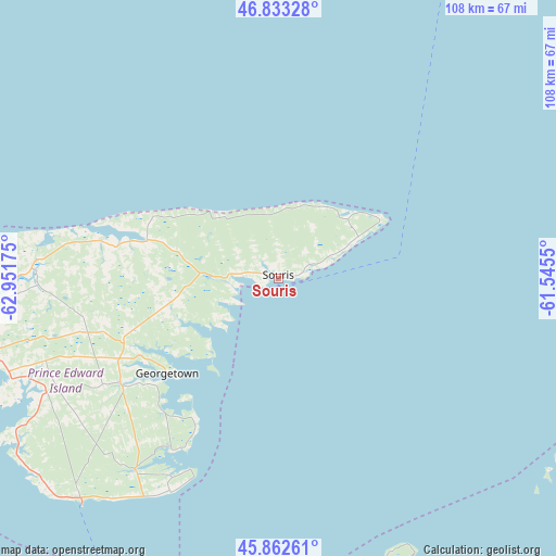
Souris GPS coordinates[2]
46° 21' 0.36" North, 62° 14' 55.032" West
| Map corner | latitude | longitude |
|---|---|---|
| Upper-left | 46.83328°, | -62.95175° |
| Center: | 46.3501°, | -62.24862° |
| Lower-right: | 45.86261°, | -61.5455° |
| Map W x H: | 107.9×107.9 km | = 67×67mi |
| max Lat: | 73.03752° ⇑56.8% North |
| Souris: | 46.3501° |
| min Lat: | ⇓43.2% South 42.05009° |
| min Long | Souris | max Long |
| -139.43328° | -62.24862° | -52.70931° |
| W 96%⇐ | ⇒4% E |
Elevation
Elevation of Souris is 8 m = 26 ft, and this is 246.4 m = 808 ft below average elevation for this country.
| Max E: |
1518 m = 4980 ft | 95.1% |
| Avg. | 254.4 m = 835 ft | |
| Souris | 8 m = 26 ft | |
Min E: |
-2 m = -7 ft | 4.9% |
See also: Canada elevation on elevation.city.
Geographical zone
Souris is located in North temperate zone (between Tropic of Cancer and the Arctic Circle). Distance of this North polar circle is 2247.5 km =1396.5 mi to North.| Distance of | km | miles | from Souris |
|---|---|---|---|
| North Pole | 4853.4 | 3015.8 | to North |
| Arctic Circle | 2247.5 | 1396.5 | to North |
| Tropic Cancer | 2547.7 | 1583.1 | to South |
| Equator | 5153.6 | 3202.3 | to South |


Nearby cities:
15 places around Souris: (largest is in red/bold)
• Antigonish
83.8 km =52.1 mi,  166°
166°
• Belfast
57 km =35.4 mi,  238°
238°
• Charlottetown
69.1 km =42.9 mi,  259°
259°
• Cornwall
75.7 km =47 mi, 259°
• Eskasoni 3
133.6 km =83 mi,  109°
109°
• Kensington
107.8 km =67 mi,  274°
274°
• Middleton
100.6 km =62.5 mi,  225°
225°
• Montague
36.9 km =22.9 mi, 236°
• New Glasgow
90.7 km =56.4 mi,  199°
199°
• Oxford
142.4 km =88.5 mi, 241°
• Pictou
82.7 km =51.4 mi,  205°
205°
• Port Hawkesbury
107.2 km =66.6 mi,  139°
139°
• Princeville
97.9 km =60.8 mi,  131°
131°
• Summerside
118.2 km =73.4 mi, 272°
• Truro
134.7 km =83.7 mi,  215°
215°
Sources, notices
• [Note1] Compared only with cities in Canada existing in our database
• [Src1] Map data: © OpenStreetMap contributors (CC-BY-SA)
• [Src2] Other city data from geonames.org with taken over terms of usage.
• [Src3] Geographical zone / Annual Mean Temperature by Robert A. Rohde @ Wikipedia
