Yverdon-les-Bains geodata
Yverdon-les-Bains (Vaud) is a seat of a second-order administrative division; located in Switzerland in Europe/Zurich (GMT+2) time zone. With population of 23,702 people, there are 33 cities with bigger population in this country. Compared to other cities in Switzerland, 75.6% of cities are located further ↑North; 93.4% of cities are located further →East and 70.8% of cities have higher elevation than Yverdon-les-Bains. Note1
Administrative division(s):
- Level 1: Vaud
- Level 2: Jura-Nord vaudois District
- Level 3: Yverdon-les-Bains


Yverdon-les-Bains GPS coordinates[2]
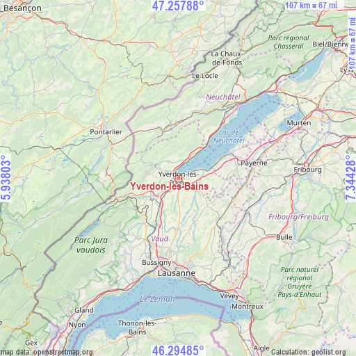
46° 46' 42.672" North, 6° 38' 28.14" East
| Map corner | latitude | longitude |
|---|---|---|
| Upper-left | 47.25788°, | 5.93803° |
| Center: | 46.77852°, | 6.64115° |
| Lower-right: | 46.29485°, | 7.34428° |
| Map W x H: | 107.1×107.1 km | = 66.5×66.5mi |
| max Lat: | 47.76737° ⇑75.6% North |
| Yverdon-les-Bains: | 46.77852° |
| min Lat: | ⇓24.4% South 45.83203° |
| min Long | Yverdon-les-Bai | max Long |
| 5.97153° | 6.64115° | 10.44624° |
| W 6.6%⇐ | ⇒93.4% E |
Elevation
Elevation of Yverdon-les-Bains is 438 m = 1437 ft, and this is 120.2 m = 394 ft below average elevation for this country.
| Max E: |
1845 m = 6053 ft | 70.8% |
| Avg. | 558.2 m = 1831 ft | |
| Yverdon-les-Bains | 438 m = 1437 ft | |
Min E: |
197 m = 646 ft | 29.2% |
See also: Switzerland elevation on elevation.city.
Geographical zone
Yverdon-les-Bains is located in North temperate zone (between Tropic of Cancer and the Arctic Circle). Distance of this North polar circle is 2199.9 km =1367 mi to North.| Distance of | km | miles | from Yverdon-les-Bains |
|---|---|---|---|
| North Pole | 4805.8 | 2986.2 | to North |
| Arctic Circle | 2199.9 | 1367 | to North |
| Tropic Cancer | 2595.4 | 1612.7 | to South |
| Equator | 5201.3 | 3231.9 | to South |


Nearby cities:
15 places around Yverdon-les-Bains: (largest is in red/bold)
• Baulmes
9.1 km =5.7 mi,  278°
278°
• Bullet
8.8 km =5.5 mi,  311°
311°
• Champagne
6.1 km =3.8 mi,  13°
13°
• Chavornay
10.1 km =6.3 mi,  212°
212°
• Cheseaux-Noréaz
2.2 km =1.4 mi,  80°
80°
• Concise
10 km =6.2 mi,  36°
36°
• Grandson
3.5 km =2.2 mi, 6°
• Montagny
2.7 km =1.7 mi, 305°
• Orbe
10.3 km =6.4 mi,  234°
234°
• Pailly
9 km =5.6 mi,  163°
163°
• Rueyres
10.2 km =6.3 mi, 157°
• Valeyres-sous-Montagny
3.2 km =2 mi, 314°
• Villars-Burquin
7.9 km =4.9 mi,  352°
352°
• Vuarrens
10.3 km =6.4 mi,  177°
177°
• Yvonand
8.1 km =5 mi,  72°
72°
Sources, notices
• [Note1] Compared only with cities in Switzerland existing in our database
• [Src1] Map data: © OpenStreetMap contributors (CC-BY-SA)
• [Src2] Other city data from geonames.org with taken over terms of usage.
• [Src3] Geographical zone / Annual Mean Temperature by Robert A. Rohde @ Wikipedia
