Yvonand geodata
Yvonand (Vaud) is a populated place; located in Switzerland in Europe/Zurich (GMT+2) time zone. With population of 2,401 people, there are 713 cities with bigger population in this country. Compared to other cities in Switzerland, 74.5% of cities are located further ↑North; 92.2% of cities are located further →East and 73.9% of cities have higher elevation than Yvonand. Note1


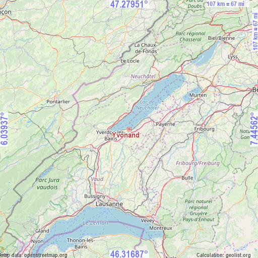
Yvonand GPS coordinates[2]
46° 48' 1.224" North, 6° 44' 32.964" East
| Map corner | latitude | longitude |
|---|---|---|
| Upper-left | 47.27951°, | 6.03937° |
| Center: | 46.80034°, | 6.74249° |
| Lower-right: | 46.31687°, | 7.44562° |
| Map W x H: | 107×107 km | = 66.5×66.5mi |
| max Lat: | 47.76737° ⇑74.5% North |
| Yvonand: | 46.80034° |
| min Lat: | ⇓25.5% South 45.83203° |
| min Long | Yvonand | max Long |
| 5.97153° | 6.74249° | 10.44624° |
| W 7.8%⇐ | ⇒92.2% E |
Elevation
Elevation of Yvonand is 433 m = 1421 ft, and this is 125.2 m = 411 ft below average elevation for this country.
| Max E: |
1845 m = 6053 ft | 73.9% |
| Avg. | 558.2 m = 1831 ft | |
| Yvonand | 433 m = 1421 ft | |
Min E: |
197 m = 646 ft | 26.1% |
See also: Switzerland elevation on elevation.city.
Geographical zone
Yvonand is located in North temperate zone (between Tropic of Cancer and the Arctic Circle). Distance of this North polar circle is 2197.5 km =1365.5 mi to North.| Distance of | km | miles | from Yvonand |
|---|---|---|---|
| North Pole | 4803.4 | 2984.7 | to North |
| Arctic Circle | 2197.5 | 1365.5 | to North |
| Tropic Cancer | 2597.8 | 1614.2 | to South |
| Equator | 5203.7 | 3233.4 | to South |


Nearby cities:
15 places around Yvonand: (largest is in red/bold)
• Champagne
7.2 km =4.5 mi,  299°
299°
• Cheseaux-Noréaz
5.9 km =3.7 mi,  249°
249°
• Cheyres
3.7 km =2.3 mi,  65°
65°
• Concise
5.8 km =3.6 mi,  342°
342°
• Cugy
11.3 km =7 mi,  81°
81°
• Estavayer-le-Lac
9.6 km =6 mi,  55°
55°
• Grandson
7.4 km =4.6 mi,  277°
277°
• Lully
8.7 km =5.4 mi, 64°
• Montagny
10 km =6.2 mi,  265°
265°
• Saint-Aubin-Sauges
10.7 km =6.6 mi,  12°
12°
• Surpierre
10.7 km =6.6 mi,  124°
124°
• Thierrens
10.8 km =6.7 mi,  174°
174°
• Valeyres-sous-Montagny
10 km =6.2 mi, 268°
• Villars-Burquin
10.3 km =6.4 mi, 301°
• Yverdon-les-Bains
8.1 km =5 mi, 252°
Sources, notices
• [Note1] Compared only with cities in Switzerland existing in our database
• [Src1] Map data: © OpenStreetMap contributors (CC-BY-SA)
• [Src2] Other city data from geonames.org with taken over terms of usage.
• [Src3] Geographical zone / Annual Mean Temperature by Robert A. Rohde @ Wikipedia
