Chavornay geodata
Chavornay (Vaud) is a populated place; located in Switzerland in Europe/Zurich (GMT+2) time zone. With population of 2,841 people, there are 618 cities with bigger population in this country. Compared to other cities in Switzerland, 78.2% of cities are located further ↑North; 94.5% of cities are located further →East and 59.8% of cities have higher elevation than Chavornay. Note1


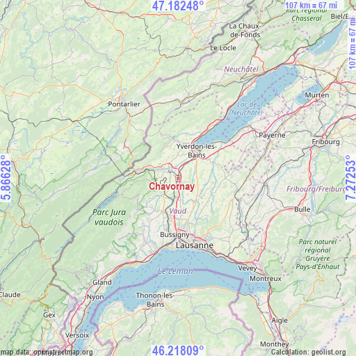
Chavornay GPS coordinates[2]
46° 42' 8.784" North, 6° 34' 9.84" East
| Map corner | latitude | longitude |
|---|---|---|
| Upper-left | 47.18248°, | 5.86628° |
| Center: | 46.70244°, | 6.5694° |
| Lower-right: | 46.21809°, | 7.27253° |
| Map W x H: | 107.2×107.2 km | = 66.6×66.6mi |
| max Lat: | 47.76737° ⇑78.2% North |
| Chavornay: | 46.70244° |
| min Lat: | ⇓21.8% South 45.83203° |
| min Long | Chavornay | max Long |
| 5.97153° | 6.5694° | 10.44624° |
| W 5.5%⇐ | ⇒94.5% E |
Elevation
Elevation of Chavornay is 455 m = 1493 ft, and this is 103.2 m = 339 ft below average elevation for this country.
| Max E: |
1845 m = 6053 ft | 59.8% |
| Avg. | 558.2 m = 1831 ft | |
| Chavornay | 455 m = 1493 ft | |
Min E: |
197 m = 646 ft | 40.2% |
See also: Switzerland elevation on elevation.city.
Geographical zone
Chavornay is located in North temperate zone (between Tropic of Cancer and the Arctic Circle). Distance of this North polar circle is 2208.3 km =1372.2 mi to North.| Distance of | km | miles | from Chavornay |
|---|---|---|---|
| North Pole | 4814.2 | 2991.4 | to North |
| Arctic Circle | 2208.3 | 1372.2 | to North |
| Tropic Cancer | 2586.9 | 1607.4 | to South |
| Equator | 5192.8 | 3226.7 | to South |


Nearby cities:
15 places around Chavornay: (largest is in red/bold)
• Bavois
2.1 km =1.3 mi,  184°
184°
• Chevilly
9.7 km =6 mi,  226°
226°
• Daillens
9.2 km =5.7 mi,  189°
189°
• Echallens
8.4 km =5.2 mi,  144°
144°
• Ferreyres
8.1 km =5 mi, 232°
• Goumoens-la-Ville
5.5 km =3.4 mi,  151°
151°
• La Sarraz
6.6 km =4.1 mi,  222°
222°
• Les Clées
8.8 km =5.5 mi,  292°
292°
• Orbe
3.9 km =2.4 mi,  310°
310°
• Orny
5.1 km =3.2 mi, 220°
• Pailly
8.1 km =5 mi,  90°
90°
• Penthéréaz
3.5 km =2.2 mi,  131°
131°
• Pompaples
6 km =3.7 mi, 229°
• Rueyres
9.4 km =5.8 mi,  96°
96°
• Vuarrens
6.3 km =3.9 mi,  107°
107°
Sources, notices
• [Note1] Compared only with cities in Switzerland existing in our database
• [Src1] Map data: © OpenStreetMap contributors (CC-BY-SA)
• [Src2] Other city data from geonames.org with taken over terms of usage.
• [Src3] Geographical zone / Annual Mean Temperature by Robert A. Rohde @ Wikipedia
