Cheseaux-Noréaz geodata
Cheseaux-Noréaz (Vaud) is a seat of a third-order administrative division; located in Switzerland in Europe/Zurich (GMT+2) time zone. In our database, there are 1823 cities with bigger population. Compared to other cities in Switzerland, 75.4% of cities are located further ↑North; 93% of cities are located further →East and 68.9% of cities have lower elevation than Cheseaux-Noréaz. Note1
Administrative division(s):
- Level 1: Vaud
- Level 2: Jura-Nord vaudois District
- Level 3: Cheseaux-Noréaz


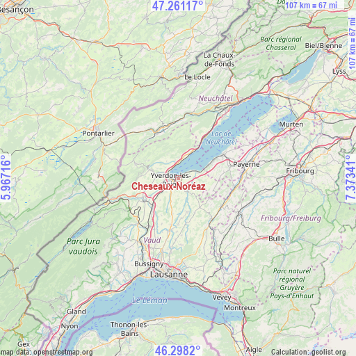
Cheseaux-Noréaz GPS coordinates[2]
46° 46' 54.624" North, 6° 40' 13.044" East
| Map corner | latitude | longitude |
|---|---|---|
| Upper-left | 47.26117°, | 5.96716° |
| Center: | 46.78184°, | 6.67029° |
| Lower-right: | 46.2982°, | 7.37341° |
| Map W x H: | 107.1×107.1 km | = 66.5×66.5mi |
| max Lat: | 47.76737° ⇑75.4% North |
| Cheseaux-Noréaz: | 46.78184° |
| min Lat: | ⇓24.6% South 45.83203° |
| min Long | Cheseaux-Noréa | max Long |
| 5.97153° | 6.67029° | 10.44624° |
| W 7%⇐ | ⇒93% E |
Elevation
Elevation of Cheseaux-Noréaz is 567 m = 1860 ft, and this is 8.8 m = 29 ft above average elevation for this country.
| Max E: |
1845 m = 6053 ft | 31.1% |
| Cheseaux-Noréaz | 567 m 1860 ft | |
| Avg. | 558.2 m = 1831 ft | |
Min E: |
197 m = 646 ft | 68.9% |
See also: Switzerland elevation on elevation.city.
Geographical zone
Cheseaux-Noréaz is located in North temperate zone (between Tropic of Cancer and the Arctic Circle). Distance of this North polar circle is 2199.5 km =1366.7 mi to North.| Distance of | km | miles | from Cheseaux-Noréaz |
|---|---|---|---|
| North Pole | 4805.4 | 2985.9 | to North |
| Arctic Circle | 2199.5 | 1366.7 | to North |
| Tropic Cancer | 2595.7 | 1612.9 | to South |
| Equator | 5201.7 | 3232.2 | to South |


Nearby cities:
15 places around Cheseaux-Noréaz: (largest is in red/bold)
• Bercher
10.5 km =6.5 mi,  164°
164°
• Bullet
10.4 km =6.5 mi,  301°
301°
• Champagne
5.6 km =3.5 mi,  351°
351°
• Cheyres
9.6 km =6 mi,  67°
67°
• Concise
8.5 km =5.3 mi,  26°
26°
• Grandson
3.6 km =2.2 mi,  328°
328°
• Montagny
4.6 km =2.9 mi,  285°
285°
• Pailly
9 km =5.6 mi,  177°
177°
• Rueyres
10 km =6.2 mi,  170°
170°
• Thierrens
10.8 km =6.7 mi,  143°
143°
• Valeyres-sous-Montagny
4.9 km =3 mi, 292°
• Villars-Burquin
8.1 km =5 mi,  336°
336°
• Vuarrens
10.8 km =6.7 mi,  189°
189°
• Yverdon-les-Bains
2.2 km =1.4 mi,  260°
260°
• Yvonand
5.9 km =3.7 mi, 69°
Sources, notices
• [Note1] Compared only with cities in Switzerland existing in our database
• [Src1] Map data: © OpenStreetMap contributors (CC-BY-SA)
• [Src2] Other city data from geonames.org with taken over terms of usage.
• [Src3] Geographical zone / Annual Mean Temperature by Robert A. Rohde @ Wikipedia
