Pailly geodata
Pailly (Vaud) is a seat of a third-order administrative division; located in Switzerland in Europe/Zurich (GMT+2) time zone. With population of 430 people, there are 1809 cities with bigger population in this country. Compared to other cities in Switzerland, 78.2% of cities are located further ↑North; 92.9% of cities are located further →East and 78.3% of cities have lower elevation than Pailly. Note1


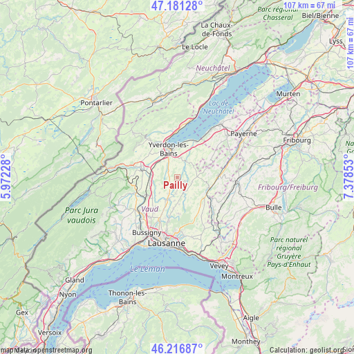
Pailly GPS coordinates[2]
46° 42' 4.428" North, 6° 40' 31.44" East
| Map corner | latitude | longitude |
|---|---|---|
| Upper-left | 47.18128°, | 5.97228° |
| Center: | 46.70123°, | 6.6754° |
| Lower-right: | 46.21687°, | 7.37853° |
| Map W x H: | 107.2×107.2 km | = 66.6×66.6mi |
| max Lat: | 47.76737° ⇑78.2% North |
| Pailly: | 46.70123° |
| min Lat: | ⇓21.8% South 45.83203° |
| min Long | Pailly | max Long |
| 5.97153° | 6.6754° | 10.44624° |
| W 7.1%⇐ | ⇒92.9% E |
Elevation
Elevation of Pailly is 644 m = 2113 ft, and this is 85.8 m = 281 ft above average elevation for this country.
| Max E: |
1845 m = 6053 ft | 21.7% |
| Pailly | 644 m 2113 ft | |
| Avg. | 558.2 m = 1831 ft | |
Min E: |
197 m = 646 ft | 78.3% |
See also: Switzerland elevation on elevation.city.
Geographical zone
Pailly is located in North temperate zone (between Tropic of Cancer and the Arctic Circle). Distance of this North polar circle is 2208.5 km =1372.3 mi to North.| Distance of | km | miles | from Pailly |
|---|---|---|---|
| North Pole | 4814.4 | 2991.5 | to North |
| Arctic Circle | 2208.5 | 1372.3 | to North |
| Tropic Cancer | 2586.8 | 1607.4 | to South |
| Equator | 5192.7 | 3226.6 | to South |


Nearby cities:
15 places around Pailly: (largest is in red/bold)
• Assens
10.6 km =6.6 mi,  202°
202°
• Bavois
8.5 km =5.3 mi,  256°
256°
• Bercher
2.7 km =1.7 mi,  114°
114°
• Bottens
9.5 km =5.9 mi,  186°
186°
• Chavornay
8.1 km =5 mi,  270°
270°
• Cheseaux-Noréaz
9 km =5.6 mi,  357°
357°
• Echallens
7.4 km =4.6 mi,  205°
205°
• Goumoens-la-Ville
7.2 km =4.5 mi,  229°
229°
• Moudon
10.1 km =6.3 mi, 111°
• Penthéréaz
5.9 km =3.7 mi,  248°
248°
• Rueyres
1.5 km =0.9 mi,  124°
124°
• Sottens
7.2 km =4.5 mi,  135°
135°
• Thierrens
6.1 km =3.8 mi,  87°
87°
• Vuarrens
2.7 km =1.7 mi, 230°
• Yverdon-les-Bains
9 km =5.6 mi,  343°
343°
Sources, notices
• [Note1] Compared only with cities in Switzerland existing in our database
• [Src1] Map data: © OpenStreetMap contributors (CC-BY-SA)
• [Src2] Other city data from geonames.org with taken over terms of usage.
• [Src3] Geographical zone / Annual Mean Temperature by Robert A. Rohde @ Wikipedia
