Montagny geodata
Montagny (Vaud) is a populated place; located in Switzerland in Europe/Zurich (GMT+2) time zone. With population of 1,467 people, there are 1051 cities with bigger population in this country. Compared to other cities in Switzerland, 74.9% of cities are located further ↑North; 93.8% of cities are located further →East and 57% of cities have higher elevation than Montagny. Note1
Administrative division(s):
- Level 1: Vaud
- Level 2: Jura-Nord vaudois District
- Level 3: Montagny-près-Yverdon


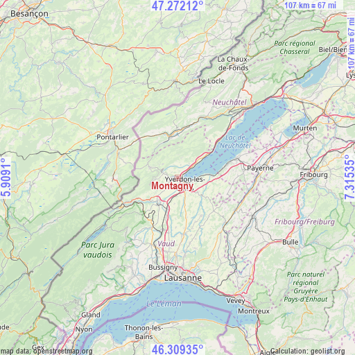
Montagny GPS coordinates[2]
46° 47' 34.404" North, 6° 36' 43.992" East
| Map corner | latitude | longitude |
|---|---|---|
| Upper-left | 47.27212°, | 5.9091° |
| Center: | 46.79289°, | 6.61222° |
| Lower-right: | 46.30935°, | 7.31535° |
| Map W x H: | 107×107 km | = 66.5×66.5mi |
| max Lat: | 47.76737° ⇑74.9% North |
| Montagny: | 46.79289° |
| min Lat: | ⇓25.1% South 45.83203° |
| min Long | Montagny | max Long |
| 5.97153° | 6.61222° | 10.44624° |
| W 6.2%⇐ | ⇒93.8% E |
Elevation
Elevation of Montagny is 462 m = 1516 ft, and this is 96.2 m = 316 ft below average elevation for this country.
| Max E: |
1845 m = 6053 ft | 57% |
| Avg. | 558.2 m = 1831 ft | |
| Montagny | 462 m = 1516 ft | |
Min E: |
197 m = 646 ft | 43% |
See also: Switzerland elevation on elevation.city.
Geographical zone
Montagny is located in North temperate zone (between Tropic of Cancer and the Arctic Circle). Distance of this North polar circle is 2198.3 km =1366 mi to North.| Distance of | km | miles | from Montagny |
|---|---|---|---|
| North Pole | 4804.2 | 2985.2 | to North |
| Arctic Circle | 2198.3 | 1366 | to North |
| Tropic Cancer | 2597 | 1613.7 | to South |
| Equator | 5202.9 | 3232.9 | to South |


Nearby cities:
15 places around Montagny: (largest is in red/bold)
• Baulmes
6.8 km =4.2 mi,  267°
267°
• Bullet
6.1 km =3.8 mi,  313°
313°
• Buttes
11.6 km =7.2 mi,  336°
336°
• Champagne
5.7 km =3.5 mi,  39°
39°
• Chavornay
10.6 km =6.6 mi,  197°
197°
• Cheseaux-Noréaz
4.6 km =2.9 mi,  105°
105°
• Concise
10.4 km =6.5 mi,  52°
52°
• Grandson
3.2 km =2 mi, 54°
• Orbe
9.8 km =6.1 mi,  219°
219°
• Pailly
11.3 km =7 mi,  154°
154°
• Sainte-Croix
8.9 km =5.5 mi,  291°
291°
• Valeyres-sous-Montagny
0.6 km =0.4 mi,  351°
351°
• Villars-Burquin
6.3 km =3.9 mi,  10°
10°
• Yverdon-les-Bains
2.7 km =1.7 mi,  125°
125°
• Yvonand
10 km =6.2 mi,  85°
85°
Sources, notices
• [Note1] Compared only with cities in Switzerland existing in our database
• [Src1] Map data: © OpenStreetMap contributors (CC-BY-SA)
• [Src2] Other city data from geonames.org with taken over terms of usage.
• [Src3] Geographical zone / Annual Mean Temperature by Robert A. Rohde @ Wikipedia
