Champagne geodata
Champagne (Vaud) is a populated place; located in Switzerland in Europe/Zurich (GMT+2) time zone. With population of 680 people, there are 1621 cities with bigger population in this country. Compared to other cities in Switzerland, 72.6% of cities are located further ↑North; 93.2% of cities are located further →East and 58.7% of cities have higher elevation than Champagne. Note1


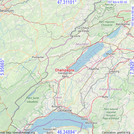
Champagne GPS coordinates[2]
46° 49' 55.668" North, 6° 39' 35.172" East
| Map corner | latitude | longitude |
|---|---|---|
| Upper-left | 47.31101°, | 5.95665° |
| Center: | 46.83213°, | 6.65977° |
| Lower-right: | 46.34894°, | 7.3629° |
| Map W x H: | 107×107 km | = 66.5×66.5mi |
| max Lat: | 47.76737° ⇑72.6% North |
| Champagne: | 46.83213° |
| min Lat: | ⇓27.4% South 45.83203° |
| min Long | Champagne | max Long |
| 5.97153° | 6.65977° | 10.44624° |
| W 6.8%⇐ | ⇒93.2% E |
Elevation
Elevation of Champagne is 457 m = 1499 ft, and this is 101.2 m = 332 ft below average elevation for this country.
| Max E: |
1845 m = 6053 ft | 58.7% |
| Avg. | 558.2 m = 1831 ft | |
| Champagne | 457 m = 1499 ft | |
Min E: |
197 m = 646 ft | 41.3% |
See also: Switzerland elevation on elevation.city.
Geographical zone
Champagne is located in North temperate zone (between Tropic of Cancer and the Arctic Circle). Distance of this North polar circle is 2193.9 km =1363.2 mi to North.| Distance of | km | miles | from Champagne |
|---|---|---|---|
| North Pole | 4799.8 | 2982.5 | to North |
| Arctic Circle | 2193.9 | 1363.2 | to North |
| Tropic Cancer | 2601.3 | 1616.4 | to South |
| Equator | 5207.2 | 3235.6 | to South |


Nearby cities:
15 places around Champagne: (largest is in red/bold)
• Bullet
8 km =5 mi,  269°
269°
• Buttes
10.3 km =6.4 mi,  307°
307°
• Cheseaux-Noréaz
5.6 km =3.5 mi,  171°
171°
• Cheyres
9.9 km =6.2 mi,  101°
101°
• Concise
5 km =3.1 mi,  66°
66°
• Couvet
10.6 km =6.6 mi,  348°
348°
• Fleurier
9.8 km =6.1 mi,  323°
323°
• Grandson
2.7 km =1.7 mi,  202°
202°
• Montagny
5.7 km =3.5 mi,  219°
219°
• Môtiers
9.5 km =5.9 mi,  337°
337°
• Saint-Aubin-Sauges
11 km =6.8 mi,  51°
51°
• Valeyres-sous-Montagny
5.3 km =3.3 mi, 224°
• Villars-Burquin
3.1 km =1.9 mi, 307°
• Yverdon-les-Bains
6.1 km =3.8 mi,  193°
193°
• Yvonand
7.2 km =4.5 mi,  119°
119°
Sources, notices
• [Note1] Compared only with cities in Switzerland existing in our database
• [Src1] Map data: © OpenStreetMap contributors (CC-BY-SA)
• [Src2] Other city data from geonames.org with taken over terms of usage.
• [Src3] Geographical zone / Annual Mean Temperature by Robert A. Rohde @ Wikipedia
