Wila geodata
Wila (Zurich) is a populated place; located in Switzerland in Europe/Zurich (GMT+2) time zone. With population of 1,387 people, there are 1092 cities with bigger population in this country. Compared to other cities in Switzerland, 77.6% of cities are located further ↓South; 82.7% of cities are located further ←West and 69.8% of cities have lower elevation than Wila. Note1


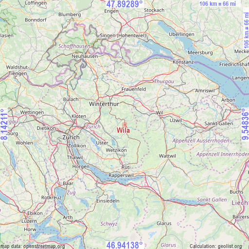
Wila GPS coordinates[2]
47° 25' 9.408" North, 8° 50' 42.864" East
| Map corner | latitude | longitude |
|---|---|---|
| Upper-left | 47.89289°, | 8.14211° |
| Center: | 47.41928°, | 8.84524° |
| Lower-right: | 46.94138°, | 9.54836° |
| Map W x H: | 105.8×105.8 km | = 65.7×65.7mi |
| max Lat: | 47.76737° ⇑22.4% North |
| Wila: | 47.41928° |
| min Lat: | ⇓77.6% South 45.83203° |
| min Long | Wila | max Long |
| 5.97153° | 8.84524° | 10.44624° |
| W 82.7%⇐ | ⇒17.3% E |
Elevation
Elevation of Wila is 572 m = 1877 ft, and this is 13.8 m = 45 ft above average elevation for this country.
| Max E: |
1845 m = 6053 ft | 30.2% |
| Wila | 572 m 1877 ft | |
| Avg. | 558.2 m = 1831 ft | |
Min E: |
197 m = 646 ft | 69.8% |
See also: Switzerland elevation on elevation.city.
Geographical zone
Wila is located in North temperate zone (between Tropic of Cancer and the Arctic Circle). Distance of this North polar circle is 2128.6 km =1322.7 mi to North.| Distance of | km | miles | from Wila |
|---|---|---|---|
| North Pole | 4734.5 | 2941.9 | to North |
| Arctic Circle | 2128.6 | 1322.7 | to North |
| Tropic Cancer | 2666.6 | 1656.9 | to South |
| Equator | 5272.5 | 3276.2 | to South |


Nearby cities:
15 places around Wila: (largest is in red/bold)
• Altlandenberg
5.5 km =3.4 mi,  161°
161°
• Bauma
6.3 km =3.9 mi, 156°
• Hittnau / Hittnau (Dorf)
6.4 km =4 mi,  194°
194°
• Kollbrunn
6.4 km =4 mi,  312°
312°
• Kollbrunn / Kollbrunn (Dorfkern)
6.8 km =4.2 mi, 308°
• Oberhittnau
6.9 km =4.3 mi, 193°
• Pfäffikon
7.3 km =4.5 mi,  213°
213°
• Pfäffikon / Pfäffikon (Dorfkern)
7.3 km =4.5 mi,  220°
220°
• Rikon / Rikon (Dorfkern)
4.6 km =2.9 mi, 309°
• Russikon
5.8 km =3.6 mi,  244°
244°
• Rämismühle
2.8 km =1.7 mi,  321°
321°
• Saland
3.2 km =2 mi,  169°
169°
• Seen (Kreis 3) / Iberg
7.2 km =4.5 mi, 314°
• Turbenthal
1.9 km =1.2 mi,  2°
2°
• Weisslingen
6 km =3.7 mi,  282°
282°
Sources, notices
• [Note1] Compared only with cities in Switzerland existing in our database
• [Src1] Map data: © OpenStreetMap contributors (CC-BY-SA)
• [Src2] Other city data from geonames.org with taken over terms of usage.
• [Src3] Geographical zone / Annual Mean Temperature by Robert A. Rohde @ Wikipedia
