Reichenburg geodata
Reichenburg (Schwyz) is a populated place; located in Switzerland in Europe/Zurich (GMT+2) time zone. With population of 2,876 people, there are 610 cities with bigger population in this country. Compared to other cities in Switzerland, 55% of cities are located further ↑North; 87.2% of cities are located further ←West and 77.1% of cities have higher elevation than Reichenburg. Note1


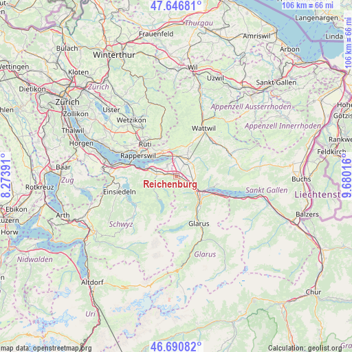
Reichenburg GPS coordinates[2]
47° 10' 15.492" North, 8° 58' 37.344" East
| Map corner | latitude | longitude |
|---|---|---|
| Upper-left | 47.64681°, | 8.27391° |
| Center: | 47.17097°, | 8.97704° |
| Lower-right: | 46.69082°, | 9.68016° |
| Map W x H: | 106.3×106.3 km | = 66.1×66.1mi |
| max Lat: | 47.76737° ⇑55% North |
| Reichenburg: | 47.17097° |
| min Lat: | ⇓45% South 45.83203° |
| min Long | Reichenburg | max Long |
| 5.97153° | 8.97704° | 10.44624° |
| W 87.2%⇐ | ⇒12.8% E |
Elevation
Elevation of Reichenburg is 427 m = 1401 ft, and this is 131.2 m = 430 ft below average elevation for this country.
| Max E: |
1845 m = 6053 ft | 77.1% |
| Avg. | 558.2 m = 1831 ft | |
| Reichenburg | 427 m = 1401 ft | |
Min E: |
197 m = 646 ft | 22.9% |
See also: Switzerland elevation on elevation.city.
Geographical zone
Reichenburg is located in North temperate zone (between Tropic of Cancer and the Arctic Circle). Distance of this North polar circle is 2156.3 km =1339.9 mi to North.| Distance of | km | miles | from Reichenburg |
|---|---|---|---|
| North Pole | 4762.1 | 2959 | to North |
| Arctic Circle | 2156.3 | 1339.9 | to North |
| Tropic Cancer | 2639 | 1639.8 | to South |
| Equator | 5244.9 | 3259 | to South |


Nearby cities:
15 places around Reichenburg: (largest is in red/bold)
• Benken
3.9 km =2.4 mi,  35°
35°
• Bilten
4.3 km =2.7 mi,  122°
122°
• Eschenbach
8.7 km =5.4 mi,  331°
331°
• Gommiswald
7.6 km =4.7 mi,  27°
27°
• Kaltbrunn
6 km =3.7 mi, 37°
• Niederurnen
7.7 km =4.8 mi,  130°
130°
• Oberurnen
8.8 km =5.5 mi,  135°
135°
• Sankt Gallenkappel
8.1 km =5 mi,  353°
353°
• Schmerikon
6.4 km =4 mi,  340°
340°
• Schänis
5.3 km =3.3 mi,  103°
103°
• Schübelbach
3.7 km =2.3 mi,  273°
273°
• Siebnen
6 km =3.7 mi, 273°
• Tuggen
4.1 km =2.5 mi, 329°
• Uznach
5.9 km =3.7 mi,  4°
4°
• Vorderthal
7.9 km =4.9 mi,  225°
225°
Sources, notices
• [Note1] Compared only with cities in Switzerland existing in our database
• [Src1] Map data: © OpenStreetMap contributors (CC-BY-SA)
• [Src2] Other city data from geonames.org with taken over terms of usage.
• [Src3] Geographical zone / Annual Mean Temperature by Robert A. Rohde @ Wikipedia
