Kaltbrunn geodata
Kaltbrunn (Saint Gallen) is a populated place; located in Switzerland in Europe/Zurich (GMT+2) time zone. With population of 3,803 people, there are 468 cities with bigger population in this country. Compared to other cities in Switzerland, 51.5% of cities are located further ↑North; 89.2% of cities are located further ←West and 67.9% of cities have higher elevation than Kaltbrunn. Note1


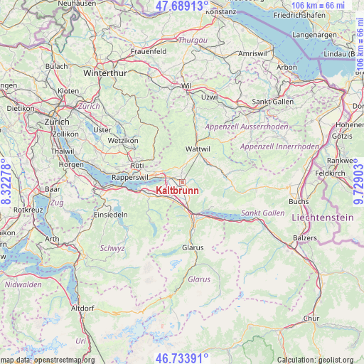
Kaltbrunn GPS coordinates[2]
47° 12' 49.212" North, 9° 1' 33.24" East
| Map corner | latitude | longitude |
|---|---|---|
| Upper-left | 47.68913°, | 8.32278° |
| Center: | 47.21367°, | 9.0259° |
| Lower-right: | 46.73391°, | 9.72903° |
| Map W x H: | 106.2×106.2 km | = 66×66mi |
| max Lat: | 47.76737° ⇑51.5% North |
| Kaltbrunn: | 47.21367° |
| min Lat: | ⇓48.5% South 45.83203° |
| min Long | Kaltbrunn | max Long |
| 5.97153° | 9.0259° | 10.44624° |
| W 89.2%⇐ | ⇒10.8% E |
Elevation
Elevation of Kaltbrunn is 441 m = 1447 ft, and this is 117.2 m = 385 ft below average elevation for this country.
| Max E: |
1845 m = 6053 ft | 67.9% |
| Avg. | 558.2 m = 1831 ft | |
| Kaltbrunn | 441 m = 1447 ft | |
Min E: |
197 m = 646 ft | 32.1% |
See also: Switzerland elevation on elevation.city.
Geographical zone
Kaltbrunn is located in North temperate zone (between Tropic of Cancer and the Arctic Circle). Distance of this North polar circle is 2151.5 km =1336.9 mi to North.| Distance of | km | miles | from Kaltbrunn |
|---|---|---|---|
| North Pole | 4757.4 | 2956.1 | to North |
| Arctic Circle | 2151.5 | 1336.9 | to North |
| Tropic Cancer | 2643.7 | 1642.7 | to South |
| Equator | 5249.7 | 3262 | to South |


Nearby cities:
15 places around Kaltbrunn: (largest is in red/bold)
• Benken
2.1 km =1.3 mi,  221°
221°
• Bilten
7.1 km =4.4 mi,  180°
180°
• Ebnat-Kappel
9.2 km =5.7 mi,  54°
54°
• Eschenbach
8.4 km =5.2 mi,  290°
290°
• Goldingen
7.5 km =4.7 mi,  319°
319°
• Gommiswald
2 km =1.2 mi,  354°
354°
• Laupen
9.3 km =5.8 mi,  307°
307°
• Niederurnen
10 km =6.2 mi,  167°
167°
• Reichenburg
6 km =3.7 mi, 217°
• Sankt Gallenkappel
5.7 km =3.5 mi, 305°
• Schmerikon
6 km =3.7 mi,  282°
282°
• Schänis
6.2 km =3.9 mi, 166°
• Schübelbach
8.6 km =5.3 mi,  238°
238°
• Tuggen
5.9 km =3.7 mi,  258°
258°
• Uznach
3.5 km =2.2 mi, 289°
Sources, notices
• [Note1] Compared only with cities in Switzerland existing in our database
• [Src1] Map data: © OpenStreetMap contributors (CC-BY-SA)
• [Src2] Other city data from geonames.org with taken over terms of usage.
• [Src3] Geographical zone / Annual Mean Temperature by Robert A. Rohde @ Wikipedia
