Krauchthal geodata
Krauchthal (Bern) is a populated place; located in Switzerland in Europe/Zurich (GMT+2) time zone. With population of 2,339 people, there are 727 cities with bigger population in this country. Compared to other cities in Switzerland, 64.1% of cities are located further ↑North; 73.1% of cities are located further →East and 71.4% of cities have lower elevation than Krauchthal. Note1


Krauchthal GPS coordinates[2]
47° 0' 34.704" North, 7° 33' 59.04" East
| Map corner | latitude | longitude |
|---|---|---|
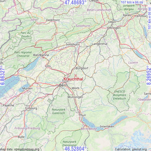
| Upper-left | 47.48693°, | 6.86327° |
| Center: | 47.00964°, | 7.5664° |
| Lower-right: | 46.52804°, | 8.26952° |
| Map W x H: | 106.6×106.6 km | = 66.2×66.2mi |
| max Lat: | 47.76737° ⇑64.1% North |
| Krauchthal: | 47.00964° |
| min Lat: | ⇓35.9% South 45.83203° |
| min Long | Krauchthal | max Long |
| 5.97153° | 7.5664° | 10.44624° |
| W 26.9%⇐ | ⇒73.1% E |
Elevation
Elevation of Krauchthal is 583 m = 1913 ft, and this is 24.8 m = 81 ft above average elevation for this country.
| Max E: |
1845 m = 6053 ft | 28.6% |
| Krauchthal | 583 m 1913 ft | |
| Avg. | 558.2 m = 1831 ft | |
Min E: |
197 m = 646 ft | 71.4% |
See also: Switzerland elevation on elevation.city.
Geographical zone
Krauchthal is located in North temperate zone (between Tropic of Cancer and the Arctic Circle). Distance of this North polar circle is 2174.2 km =1351 mi to North.| Distance of | km | miles | from Krauchthal |
|---|---|---|---|
| North Pole | 4780.1 | 2970.2 | to North |
| Arctic Circle | 2174.2 | 1351 | to North |
| Tropic Cancer | 2621.1 | 1628.7 | to South |
| Equator | 5227 | 3247.9 | to South |


Nearby cities:
15 places around Krauchthal: (largest is in red/bold)
• Bolligen
6.5 km =4 mi,  233°
233°
• Burgdorf
7.2 km =4.5 mi,  40°
40°
• Bäriswil
3.2 km =2 mi,  290°
290°
• Hindelbank
4.1 km =2.5 mi,  332°
332°
• Jegenstorf
6.2 km =3.9 mi,  313°
313°
• Lyssach
6.2 km =3.9 mi,  11°
11°
• Oberburg
5.5 km =3.4 mi,  57°
57°
• Ostermundigen
8.2 km =5.1 mi,  224°
224°
• Rüegsau
8.3 km =5.2 mi,  78°
78°
• Rüti bei Lyssach
5.3 km =3.3 mi, 8°
• Stettlen
6.5 km =4 mi,  208°
208°
• Urtenen
5.3 km =3.3 mi, 290°
• Vechigen
7.1 km =4.4 mi,  183°
183°
• Walkringen
7.9 km =4.9 mi,  148°
148°
• Zollikofen
8.3 km =5.2 mi,  261°
261°
Sources, notices
• [Note1] Compared only with cities in Switzerland existing in our database
• [Src1] Map data: © OpenStreetMap contributors (CC-BY-SA)
• [Src2] Other city data from geonames.org with taken over terms of usage.
• [Src3] Geographical zone / Annual Mean Temperature by Robert A. Rohde @ Wikipedia
