Thundorf geodata
Thundorf (Thurgau) is a populated place; located in Switzerland in Europe/Zurich (GMT+2) time zone. With population of 1,179 people, there are 1215 cities with bigger population in this country. Compared to other cities in Switzerland, 94.6% of cities are located further ↓South; 86.6% of cities are located further ←West and 64.9% of cities have lower elevation than Thundorf. Note1


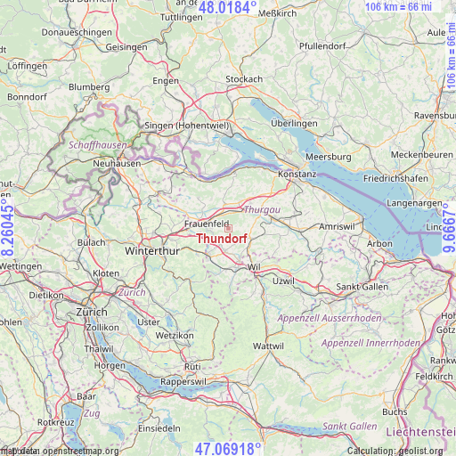
Thundorf GPS coordinates[2]
47° 32' 45.384" North, 8° 57' 48.888" East
| Map corner | latitude | longitude |
|---|---|---|
| Upper-left | 48.0184°, | 8.26045° |
| Center: | 47.54594°, | 8.96358° |
| Lower-right: | 47.06918°, | 9.6667° |
| Map W x H: | 105.5×105.5 km | = 65.6×65.6mi |
| max Lat: | 47.76737° ⇑5.4% North |
| Thundorf: | 47.54594° |
| min Lat: | ⇓94.6% South 45.83203° |
| min Long | Thundorf | max Long |
| 5.97153° | 8.96358° | 10.44624° |
| W 86.6%⇐ | ⇒13.4% E |
Elevation
Elevation of Thundorf is 546 m = 1791 ft, and this is 12.2 m = 40 ft below average elevation for this country.
| Max E: |
1845 m = 6053 ft | 35.1% |
| Avg. | 558.2 m = 1831 ft | |
| Thundorf | 546 m = 1791 ft | |
Min E: |
197 m = 646 ft | 64.9% |
See also: Switzerland elevation on elevation.city.
Geographical zone
Thundorf is located in North temperate zone (between Tropic of Cancer and the Arctic Circle). Distance of this North polar circle is 2114.6 km =1314 mi to North.| Distance of | km | miles | from Thundorf |
|---|---|---|---|
| North Pole | 4720.4 | 2933.1 | to North |
| Arctic Circle | 2114.6 | 1314 | to North |
| Tropic Cancer | 2680.7 | 1665.7 | to South |
| Equator | 5286.6 | 3284.9 | to South |


Nearby cities:
15 places around Thundorf: (largest is in red/bold)
• Aadorf
7.6 km =4.7 mi,  218°
218°
• Affeltrangen
5.7 km =3.5 mi,  113°
113°
• Frauenfeld
5 km =3.1 mi,  285°
285°
• Gachnang
8.3 km =5.2 mi,  264°
264°
• Hagenbuch
6.3 km =3.9 mi,  242°
242°
• Herdern
7.5 km =4.7 mi,  328°
328°
• Hüttlingen
3.8 km =2.4 mi,  19°
19°
• Lommis
4 km =2.5 mi,  142°
142°
• Matzingen
3.7 km =2.3 mi, 217°
• Müllheim
6.9 km =4.3 mi,  25°
25°
• Münchwilen
8 km =5 mi,  161°
161°
• Pfyn
5.7 km =3.5 mi,  352°
352°
• Stettfurt
2.4 km =1.5 mi,  199°
199°
• Wigoltingen
7.7 km =4.8 mi,  41°
41°
• Wängi
5.5 km =3.4 mi,  188°
188°
Sources, notices
• [Note1] Compared only with cities in Switzerland existing in our database
• [Src1] Map data: © OpenStreetMap contributors (CC-BY-SA)
• [Src2] Other city data from geonames.org with taken over terms of usage.
• [Src3] Geographical zone / Annual Mean Temperature by Robert A. Rohde @ Wikipedia
