Herdern geodata
Herdern (Thurgau) is a populated place; located in Switzerland in Europe/Zurich (GMT+2) time zone. With population of 908 people, there are 1409 cities with bigger population in this country. Compared to other cities in Switzerland, 97.2% of cities are located further ↓South; 84.8% of cities are located further ←West and 50.3% of cities have higher elevation than Herdern. Note1


Herdern GPS coordinates[2]
47° 36' 10.944" North, 8° 54' 38.772" East
| Map corner | latitude | longitude |
|---|---|---|
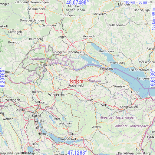
| Upper-left | 48.07498°, | 8.20765° |
| Center: | 47.60304°, | 8.91077° |
| Lower-right: | 47.1268°, | 9.6139° |
| Map W x H: | 105.4×105.4 km | = 65.5×65.5mi |
| max Lat: | 47.76737° ⇑2.8% North |
| Herdern: | 47.60304° |
| min Lat: | ⇓97.2% South 45.83203° |
| min Long | Herdern | max Long |
| 5.97153° | 8.91077° | 10.44624° |
| W 84.8%⇐ | ⇒15.2% E |
Elevation
Elevation of Herdern is 477 m = 1565 ft, and this is 81.2 m = 266 ft below average elevation for this country.
| Max E: |
1845 m = 6053 ft | 50.3% |
| Avg. | 558.2 m = 1831 ft | |
| Herdern | 477 m = 1565 ft | |
Min E: |
197 m = 646 ft | 49.7% |
See also: Switzerland elevation on elevation.city.
Geographical zone
Herdern is located in North temperate zone (between Tropic of Cancer and the Arctic Circle). Distance of this North polar circle is 2108.2 km =1310 mi to North.| Distance of | km | miles | from Herdern |
|---|---|---|---|
| North Pole | 4714.1 | 2929.2 | to North |
| Arctic Circle | 2108.2 | 1310 | to North |
| Tropic Cancer | 2687 | 1669.6 | to South |
| Equator | 5293 | 3288.9 | to South |


Nearby cities:
15 places around Herdern: (largest is in red/bold)
• Eschenz
5.7 km =3.5 mi,  331°
331°
• Frauenfeld
5.1 km =3.2 mi,  190°
190°
• Gachnang
8.3 km =5.2 mi,  211°
211°
• Homburg
8.1 km =5 mi,  64°
64°
• Hüttlingen
5.9 km =3.7 mi,  117°
117°
• Hüttwilen
2.8 km =1.7 mi,  278°
278°
• Mammern
4.8 km =3 mi,  3°
3°
• Müllheim
7 km =4.3 mi,  90°
90°
• Oberstammheim
8.9 km =5.5 mi,  291°
291°
• Pfyn
3.3 km =2.1 mi,  101°
101°
• Steckborn
8.9 km =5.5 mi,  37°
37°
• Stein am Rhein
7.3 km =4.5 mi, 328°
• Thundorf
7.5 km =4.7 mi,  148°
148°
• Wagenhausen
7.9 km =4.9 mi,  323°
323°
• Wigoltingen
9.1 km =5.7 mi, 93°
Sources, notices
• [Note1] Compared only with cities in Switzerland existing in our database
• [Src1] Map data: © OpenStreetMap contributors (CC-BY-SA)
• [Src2] Other city data from geonames.org with taken over terms of usage.
• [Src3] Geographical zone / Annual Mean Temperature by Robert A. Rohde @ Wikipedia
