Pfyn geodata
Pfyn (Thurgau) is a populated place; located in Switzerland in Europe/Zurich (GMT+2) time zone. With population of 1,839 people, there are 894 cities with bigger population in this country. Compared to other cities in Switzerland, 97% of cities are located further ↓South; 86.3% of cities are located further ←West and 85.1% of cities have higher elevation than Pfyn. Note1


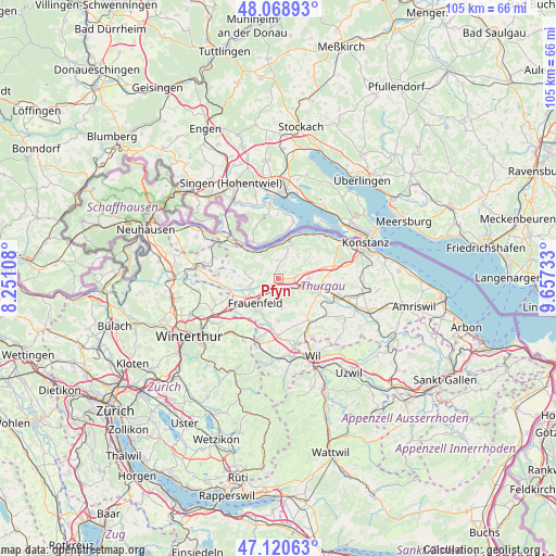
Pfyn GPS coordinates[2]
47° 35' 48.948" North, 8° 57' 15.12" East
| Map corner | latitude | longitude |
|---|---|---|
| Upper-left | 48.06893°, | 8.25108° |
| Center: | 47.59693°, | 8.9542° |
| Lower-right: | 47.12063°, | 9.65733° |
| Map W x H: | 105.4×105.4 km | = 65.5×65.5mi |
| max Lat: | 47.76737° ⇑3% North |
| Pfyn: | 47.59693° |
| min Lat: | ⇓97% South 45.83203° |
| min Long | Pfyn | max Long |
| 5.97153° | 8.9542° | 10.44624° |
| W 86.3%⇐ | ⇒13.7% E |
Elevation
Elevation of Pfyn is 410 m = 1345 ft, and this is 148.2 m = 486 ft below average elevation for this country.
| Max E: |
1845 m = 6053 ft | 85.1% |
| Avg. | 558.2 m = 1831 ft | |
| Pfyn | 410 m = 1345 ft | |
Min E: |
197 m = 646 ft | 14.9% |
See also: Switzerland elevation on elevation.city.
Geographical zone
Pfyn is located in North temperate zone (between Tropic of Cancer and the Arctic Circle). Distance of this North polar circle is 2108.9 km =1310.4 mi to North.| Distance of | km | miles | from Pfyn |
|---|---|---|---|
| North Pole | 4714.8 | 2929.6 | to North |
| Arctic Circle | 2108.9 | 1310.4 | to North |
| Tropic Cancer | 2686.4 | 1669.3 | to South |
| Equator | 5292.3 | 3288.5 | to South |


Nearby cities:
15 places around Pfyn: (largest is in red/bold)
• Eschenz
8.2 km =5.1 mi,  313°
313°
• Frauenfeld
6 km =3.7 mi,  223°
223°
• Herdern
3.3 km =2.1 mi,  281°
281°
• Homburg
5.8 km =3.6 mi,  43°
43°
• Hüttlingen
2.9 km =1.8 mi,  136°
136°
• Hüttwilen
6.2 km =3.9 mi, 280°
• Lommis
9.4 km =5.8 mi,  160°
160°
• Mammern
6.2 km =3.9 mi,  331°
331°
• Matzingen
8.7 km =5.4 mi,  190°
190°
• Märstetten-Dorf
8.6 km =5.3 mi,  93°
93°
• Müllheim
3.7 km =2.3 mi,  81°
81°
• Steckborn
8.1 km =5 mi,  15°
15°
• Stettfurt
7.9 km =4.9 mi,  180°
180°
• Thundorf
5.7 km =3.5 mi,  172°
172°
• Wigoltingen
5.8 km =3.6 mi, 89°
Sources, notices
• [Note1] Compared only with cities in Switzerland existing in our database
• [Src1] Map data: © OpenStreetMap contributors (CC-BY-SA)
• [Src2] Other city data from geonames.org with taken over terms of usage.
• [Src3] Geographical zone / Annual Mean Temperature by Robert A. Rohde @ Wikipedia
