Heiligenschwendi geodata
Heiligenschwendi (Bern) is a populated place; located in Switzerland in Europe/Zurich (GMT+2) time zone. With population of 674 people, there are 1627 cities with bigger population in this country. Compared to other cities in Switzerland, 76.6% of cities are located further ↑North; 68.8% of cities are located further →East and 96.8% of cities have lower elevation than Heiligenschwendi. Note1


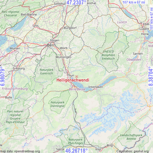
Heiligenschwendi GPS coordinates[2]
46° 45' 3.924" North, 7° 41' 2.076" East
| Map corner | latitude | longitude |
|---|---|---|
| Upper-left | 47.2307°, | 6.98079° |
| Center: | 46.75109°, | 7.68391° |
| Lower-right: | 46.26718°, | 8.38704° |
| Map W x H: | 107.1×107.1 km | = 66.5×66.5mi |
| max Lat: | 47.76737° ⇑76.6% North |
| Heiligenschwendi: | 46.75109° |
| min Lat: | ⇓23.4% South 45.83203° |
| min Long | Heiligenschwend | max Long |
| 5.97153° | 7.68391° | 10.44624° |
| W 31.2%⇐ | ⇒68.8% E |
Elevation
Elevation of Heiligenschwendi is 1144 m = 3753 ft, and this is 585.8 m = 1922 ft above average elevation for this country.
| Max E: |
1845 m = 6053 ft | 3.2% |
| Heiligenschwendi | 1144 m 3753 ft | |
| Avg. | 558.2 m = 1831 ft | |
Min E: |
197 m = 646 ft | 96.8% |
See also: Switzerland elevation on elevation.city.
Geographical zone
Heiligenschwendi is located in North temperate zone (between Tropic of Cancer and the Arctic Circle). Distance of this North polar circle is 2202.9 km =1368.8 mi to North.| Distance of | km | miles | from Heiligenschwendi |
|---|---|---|---|
| North Pole | 4808.8 | 2988 | to North |
| Arctic Circle | 2202.9 | 1368.8 | to North |
| Tropic Cancer | 2592.3 | 1610.8 | to South |
| Equator | 5198.2 | 3230 | to South |


Nearby cities:
15 places around Heiligenschwendi: (largest is in red/bold)
• Amsoldingen
8.2 km =5.1 mi,  251°
251°
• Buchholterberg
7 km =4.3 mi,  354°
354°
• Eriz
7.8 km =4.8 mi,  58°
58°
• Fahrni
5.3 km =3.3 mi,  335°
335°
• Heimberg
7.8 km =4.8 mi,  308°
308°
• Hilterfingen
2.4 km =1.5 mi,  223°
223°
• Reutigen
8 km =5 mi, 216°
• Sigriswil
4.4 km =2.7 mi,  149°
149°
• Spiez
7.4 km =4.6 mi,  175°
175°
• Steffisburg
4.9 km =3 mi, 307°
• Thierachern
8.3 km =5.2 mi,  271°
271°
• Thun
4.7 km =2.9 mi, 270°
• Uetendorf
8.9 km =5.5 mi,  286°
286°
• Uttigen
9.4 km =5.8 mi,  300°
300°
• Wimmis
9 km =5.6 mi,  201°
201°
Sources, notices
• [Note1] Compared only with cities in Switzerland existing in our database
• [Src1] Map data: © OpenStreetMap contributors (CC-BY-SA)
• [Src2] Other city data from geonames.org with taken over terms of usage.
• [Src3] Geographical zone / Annual Mean Temperature by Robert A. Rohde @ Wikipedia
