Amsoldingen geodata
Amsoldingen (Bern) is a populated place; located in Switzerland in Europe/Zurich (GMT+2) time zone. With population of 775 people, there are 1509 cities with bigger population in this country. Compared to other cities in Switzerland, 77.5% of cities are located further ↑North; 72.3% of cities are located further →East and 78% of cities have lower elevation than Amsoldingen. Note1


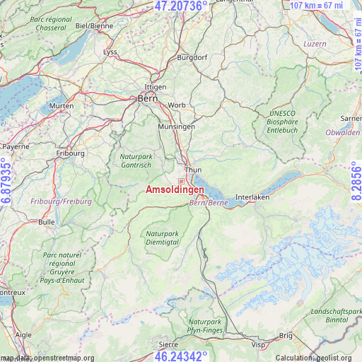
Amsoldingen GPS coordinates[2]
46° 43' 39.144" North, 7° 34' 56.892" East
| Map corner | latitude | longitude |
|---|---|---|
| Upper-left | 47.20736°, | 6.87935° |
| Center: | 46.72754°, | 7.58247° |
| Lower-right: | 46.24342°, | 8.2856° |
| Map W x H: | 107.2×107.2 km | = 66.6×66.6mi |
| max Lat: | 47.76737° ⇑77.5% North |
| Amsoldingen: | 46.72754° |
| min Lat: | ⇓22.5% South 45.83203° |
| min Long | Amsoldingen | max Long |
| 5.97153° | 7.58247° | 10.44624° |
| W 27.7%⇐ | ⇒72.3% E |
Elevation
Elevation of Amsoldingen is 641 m = 2103 ft, and this is 82.8 m = 272 ft above average elevation for this country.
| Max E: |
1845 m = 6053 ft | 22% |
| Amsoldingen | 641 m 2103 ft | |
| Avg. | 558.2 m = 1831 ft | |
Min E: |
197 m = 646 ft | 78% |
See also: Switzerland elevation on elevation.city.
Geographical zone
Amsoldingen is located in North temperate zone (between Tropic of Cancer and the Arctic Circle). Distance of this North polar circle is 2205.6 km =1370.5 mi to North.| Distance of | km | miles | from Amsoldingen |
|---|---|---|---|
| North Pole | 4811.4 | 2989.7 | to North |
| Arctic Circle | 2205.6 | 1370.5 | to North |
| Tropic Cancer | 2589.7 | 1609.2 | to South |
| Equator | 5195.6 | 3228.4 | to South |


Nearby cities:
15 places around Amsoldingen: (largest is in red/bold)
• Blumenstein
4.9 km =3 mi,  289°
289°
• Erlenbach im Simmental
7.8 km =4.8 mi,  195°
195°
• Heiligenschwendi
8.2 km =5.1 mi,  71°
71°
• Heimberg
7.7 km =4.8 mi,  12°
12°
• Hilterfingen
6.1 km =3.8 mi,  81°
81°
• Reutigen
4.8 km =3 mi,  142°
142°
• Seftigen
7.4 km =4.6 mi,  333°
333°
• Steffisburg
6.8 km =4.2 mi,  34°
34°
• Thierachern
2.9 km =1.8 mi,  347°
347°
• Thun
4 km =2.5 mi,  48°
48°
• Uebeschi
2.3 km =1.4 mi,  299°
299°
• Uetendorf
5.2 km =3.2 mi, 351°
• Uttigen
7.4 km =4.6 mi,  357°
357°
• Wattenwil
7.3 km =4.5 mi,  309°
309°
• Wimmis
7.2 km =4.5 mi, 142°
Sources, notices
• [Note1] Compared only with cities in Switzerland existing in our database
• [Src1] Map data: © OpenStreetMap contributors (CC-BY-SA)
• [Src2] Other city data from geonames.org with taken over terms of usage.
• [Src3] Geographical zone / Annual Mean Temperature by Robert A. Rohde @ Wikipedia
