Stans geodata
Stans (Nidwalden) is a seat of a first-order administrative division; located in Switzerland in Europe/Zurich (GMT+2) time zone. With population of 7,475 people, there are 219 cities with bigger population in this country. Compared to other cities in Switzerland, 66.3% of cities are located further ↑North; 51.6% of cities are located further →East and 61% of cities have higher elevation than Stans. Note1


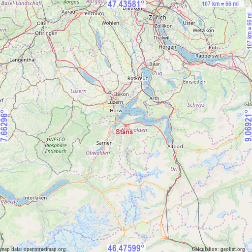
Stans GPS coordinates[2]
46° 57' 28.98" North, 8° 21' 57.924" East
| Map corner | latitude | longitude |
|---|---|---|
| Upper-left | 47.43581°, | 7.66296° |
| Center: | 46.95805°, | 8.36609° |
| Lower-right: | 46.47599°, | 9.06921° |
| Map W x H: | 106.7×106.7 km | = 66.3×66.3mi |
| max Lat: | 47.76737° ⇑66.3% North |
| Stans: | 46.95805° |
| min Lat: | ⇓33.7% South 45.83203° |
| min Long | Stans | max Long |
| 5.97153° | 8.36609° | 10.44624° |
| W 48.4%⇐ | ⇒51.6% E |
Elevation
Elevation of Stans is 453 m = 1486 ft, and this is 105.2 m = 345 ft below average elevation for this country.
| Max E: |
1845 m = 6053 ft | 61% |
| Avg. | 558.2 m = 1831 ft | |
| Stans | 453 m = 1486 ft | |
Min E: |
197 m = 646 ft | 39% |
See also: Switzerland elevation on elevation.city.
Geographical zone
Stans is located in North temperate zone (between Tropic of Cancer and the Arctic Circle). Distance of this North polar circle is 2179.9 km =1354.5 mi to North.| Distance of | km | miles | from Stans |
|---|---|---|---|
| North Pole | 4785.8 | 2973.8 | to North |
| Arctic Circle | 2179.9 | 1354.5 | to North |
| Tropic Cancer | 2615.3 | 1625.1 | to South |
| Equator | 5221.2 | 3244.3 | to South |


Nearby cities:
15 places around Stans: (largest is in red/bold)
• Alpnach
7.4 km =4.6 mi,  256°
256°
• Beckenried
8.4 km =5.2 mi,  83°
83°
• Buochs
4.7 km =2.9 mi,  67°
67°
• Dallenwil
4.1 km =2.5 mi,  156°
156°
• Ennetbürgen
4.4 km =2.7 mi,  48°
48°
• Hergiswil
5.2 km =3.2 mi,  304°
304°
• Horw
7.8 km =4.8 mi,  326°
326°
• Kerns
9.4 km =5.8 mi,  227°
227°
• Kriens
10.2 km =6.3 mi,  323°
323°
• Luzern
11.2 km =7 mi,  336°
336°
• Meggen
9.9 km =6.2 mi,  3°
3°
• Stansstad
3.1 km =1.9 mi,  311°
311°
• Vitznau
10.7 km =6.6 mi,  57°
57°
• Weggis
9.6 km =6 mi,  31°
31°
• Wolfenschiessen
6.5 km =4 mi, 160°
Sources, notices
• [Note1] Compared only with cities in Switzerland existing in our database
• [Src1] Map data: © OpenStreetMap contributors (CC-BY-SA)
• [Src2] Other city data from geonames.org with taken over terms of usage.
• [Src3] Geographical zone / Annual Mean Temperature by Robert A. Rohde @ Wikipedia
