Beckenried geodata
Beckenried (Nidwalden) is a seat of a third-order administrative division; located in Switzerland in Europe/Zurich (GMT+2) time zone. With population of 3,050 people, there are 581 cities with bigger population in this country. Compared to other cities in Switzerland, 66.1% of cities are located further ↑North; 55.6% of cities are located further ←West and 73.6% of cities have higher elevation than Beckenried. Note1


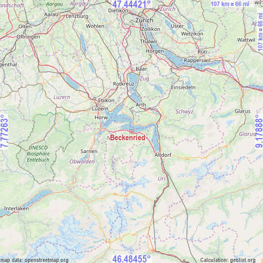
Beckenried GPS coordinates[2]
46° 57' 59.508" North, 8° 28' 32.7" East
| Map corner | latitude | longitude |
|---|---|---|
| Upper-left | 47.44421°, | 7.77263° |
| Center: | 46.96653°, | 8.47575° |
| Lower-right: | 46.48455°, | 9.17888° |
| Map W x H: | 106.7×106.7 km | = 66.3×66.3mi |
| max Lat: | 47.76737° ⇑66.1% North |
| Beckenried: | 46.96653° |
| min Lat: | ⇓33.9% South 45.83203° |
| min Long | Beckenried | max Long |
| 5.97153° | 8.47575° | 10.44624° |
| W 55.6%⇐ | ⇒44.4% E |
Elevation
Elevation of Beckenried is 434 m = 1424 ft, and this is 124.2 m = 407 ft below average elevation for this country.
| Max E: |
1845 m = 6053 ft | 73.6% |
| Avg. | 558.2 m = 1831 ft | |
| Beckenried | 434 m = 1424 ft | |
Min E: |
197 m = 646 ft | 26.4% |
See also: Switzerland elevation on elevation.city.
Geographical zone
Beckenried is located in North temperate zone (between Tropic of Cancer and the Arctic Circle). Distance of this North polar circle is 2179 km =1354 mi to North.| Distance of | km | miles | from Beckenried |
|---|---|---|---|
| North Pole | 4784.9 | 2973.2 | to North |
| Arctic Circle | 2179 | 1354 | to North |
| Tropic Cancer | 2616.3 | 1625.7 | to South |
| Equator | 5222.2 | 3244.9 | to South |


Nearby cities:
15 places around Beckenried: (largest is in red/bold)
• Bauen
8.5 km =5.3 mi,  113°
113°
• Buochs
4.1 km =2.5 mi,  281°
281°
• Dallenwil
8.2 km =5.1 mi,  234°
234°
• Emmetten
3.2 km =2 mi, 110°
• Ennetbürgen
5.4 km =3.4 mi,  291°
291°
• Gersau
4.8 km =3 mi,  50°
50°
• Goldau
10.5 km =6.5 mi,  30°
30°
• Greppen
10.4 km =6.5 mi,  340°
340°
• Isenthal
9 km =5.6 mi,  133°
133°
• Seelisberg
8.5 km =5.3 mi,  85°
85°
• Stans
8.4 km =5.2 mi,  263°
263°
• Stansstad
10.7 km =6.6 mi, 276°
• Vitznau
4.9 km =3 mi,  7°
7°
• Weggis
8 km =5 mi, 335°
• Wolfenschiessen
9.4 km =5.8 mi,  221°
221°
Sources, notices
• [Note1] Compared only with cities in Switzerland existing in our database
• [Src1] Map data: © OpenStreetMap contributors (CC-BY-SA)
• [Src2] Other city data from geonames.org with taken over terms of usage.
• [Src3] Geographical zone / Annual Mean Temperature by Robert A. Rohde @ Wikipedia
