Seltisberg geodata
Seltisberg (Basel-Landschaft) is a populated place; located in Switzerland in Europe/Zurich (GMT+2) time zone. With population of 1,412 people, there are 1076 cities with bigger population in this country. Compared to other cities in Switzerland, 84% of cities are located further ↓South; 67.8% of cities are located further →East and 55% of cities have lower elevation than Seltisberg. Note1


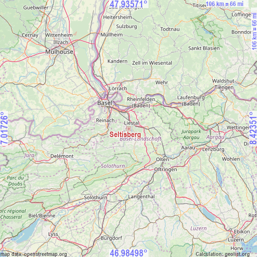
Seltisberg GPS coordinates[2]
47° 27' 44.964" North, 7° 43' 13.404" East
| Map corner | latitude | longitude |
|---|---|---|
| Upper-left | 47.93571°, | 7.01726° |
| Center: | 47.46249°, | 7.72039° |
| Lower-right: | 46.98498°, | 8.42351° |
| Map W x H: | 105.7×105.7 km | = 65.7×65.7mi |
| max Lat: | 47.76737° ⇑16% North |
| Seltisberg: | 47.46249° |
| min Lat: | ⇓84% South 45.83203° |
| min Long | Seltisberg | max Long |
| 5.97153° | 7.72039° | 10.44624° |
| W 32.2%⇐ | ⇒67.8% E |
Elevation
Elevation of Seltisberg is 496 m = 1627 ft, and this is 62.2 m = 204 ft below average elevation for this country.
| Max E: |
1845 m = 6053 ft | 45% |
| Avg. | 558.2 m = 1831 ft | |
| Seltisberg | 496 m = 1627 ft | |
Min E: |
197 m = 646 ft | 55% |
See also: Switzerland elevation on elevation.city.
Geographical zone
Seltisberg is located in North temperate zone (between Tropic of Cancer and the Arctic Circle). Distance of this North polar circle is 2123.8 km =1319.7 mi to North.| Distance of | km | miles | from Seltisberg |
|---|---|---|---|
| North Pole | 4729.7 | 2938.9 | to North |
| Arctic Circle | 2123.8 | 1319.7 | to North |
| Tropic Cancer | 2671.4 | 1659.9 | to South |
| Equator | 5277.3 | 3279.2 | to South |


Nearby cities:
15 places around Seltisberg: (largest is in red/bold)
• Arboldswil
5.4 km =3.4 mi,  182°
182°
• Arisdorf
6.6 km =4.1 mi,  30°
30°
• Bubendorf
2.3 km =1.4 mi,  145°
145°
• Frenkendorf
4.9 km =3 mi,  356°
356°
• Füllinsdorf
5 km =3.1 mi,  9°
9°
• Gempen
4.8 km =3 mi,  288°
288°
• Hochwald
5.8 km =3.6 mi,  260°
260°
• Hölstein
5.8 km =3.6 mi,  139°
139°
• Itingen
4.9 km =3 mi,  84°
84°
• Lausen
3.2 km =2 mi,  71°
71°
• Liestal
2.7 km =1.7 mi,  23°
23°
• Pratteln
6.8 km =4.2 mi,  342°
342°
• Sissach
6.7 km =4.2 mi,  88°
88°
• Tenniken
7.4 km =4.6 mi,  112°
112°
• Zunzgen
6.7 km =4.2 mi,  102°
102°
Sources, notices
• [Note1] Compared only with cities in Switzerland existing in our database
• [Src1] Map data: © OpenStreetMap contributors (CC-BY-SA)
• [Src2] Other city data from geonames.org with taken over terms of usage.
• [Src3] Geographical zone / Annual Mean Temperature by Robert A. Rohde @ Wikipedia
