Klingnau geodata
Klingnau (Aargau) is a populated place; located in Switzerland in Europe/Zurich (GMT+2) time zone. With population of 3,069 people, there are 576 cities with bigger population in this country. Compared to other cities in Switzerland, 96.4% of cities are located further ↓South; 54.2% of cities are located further →East and 96% of cities have higher elevation than Klingnau. Note1


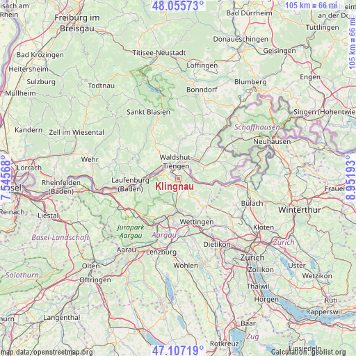
Klingnau GPS coordinates[2]
47° 35' 0.996" North, 8° 14' 55.68" East
| Map corner | latitude | longitude |
|---|---|---|
| Upper-left | 48.05573°, | 7.54568° |
| Center: | 47.58361°, | 8.2488° |
| Lower-right: | 47.10719°, | 8.95193° |
| Map W x H: | 105.5×105.5 km | = 65.6×65.6mi |
| max Lat: | 47.76737° ⇑3.6% North |
| Klingnau: | 47.58361° |
| min Lat: | ⇓96.4% South 45.83203° |
| min Long | Klingnau | max Long |
| 5.97153° | 8.2488° | 10.44624° |
| W 45.8%⇐ | ⇒54.2% E |
Elevation
Elevation of Klingnau is 335 m = 1099 ft, and this is 223.2 m = 732 ft below average elevation for this country.
| Max E: |
1845 m = 6053 ft | 96% |
| Avg. | 558.2 m = 1831 ft | |
| Klingnau | 335 m = 1099 ft | |
Min E: |
197 m = 646 ft | 4% |
See also: Switzerland elevation on elevation.city.
Geographical zone
Klingnau is located in North temperate zone (between Tropic of Cancer and the Arctic Circle). Distance of this North polar circle is 2110.4 km =1311.3 mi to North.| Distance of | km | miles | from Klingnau |
|---|---|---|---|
| North Pole | 4716.3 | 2930.6 | to North |
| Arctic Circle | 2110.4 | 1311.3 | to North |
| Tropic Cancer | 2684.9 | 1668.3 | to South |
| Equator | 5290.8 | 3287.5 | to South |


Nearby cities:
15 places around Klingnau: (largest is in red/bold)
• Bad Zurzach
3.4 km =2.1 mi,  82°
82°
• Endingen
6 km =3.7 mi,  148°
148°
• Gansingen
9.7 km =6 mi,  242°
242°
• Koblenz
3 km =1.9 mi,  343°
343°
• Lauffohr (Brugg)
9.2 km =5.7 mi,  188°
188°
• Leibstadt
5.5 km =3.4 mi,  275°
275°
• Obersiggenthal
11.3 km =7 mi,  161°
161°
• Rekingen
5.3 km =3.3 mi,  104°
104°
• Schwaderloch
7.8 km =4.8 mi,  271°
271°
• Siglistorf
10.7 km =6.6 mi,  113°
113°
• Tegerfelden
4.1 km =2.5 mi,  133°
133°
• Turgi
10.2 km =6.3 mi,  177°
177°
• Untersiggenthal
9.1 km =5.7 mi, 176°
• Villigen
6.8 km =4.2 mi,  201°
201°
• Würenlingen
5.6 km =3.5 mi,  173°
173°
Sources, notices
• [Note1] Compared only with cities in Switzerland existing in our database
• [Src1] Map data: © OpenStreetMap contributors (CC-BY-SA)
• [Src2] Other city data from geonames.org with taken over terms of usage.
• [Src3] Geographical zone / Annual Mean Temperature by Robert A. Rohde @ Wikipedia
