Leuzigen geodata
Leuzigen (Bern) is a populated place; located in Switzerland in Europe/Zurich (GMT+2) time zone. With population of 1,167 people, there are 1221 cities with bigger population in this country. Compared to other cities in Switzerland, 54.7% of cities are located further ↑North; 76.6% of cities are located further →East and 59.8% of cities have higher elevation than Leuzigen. Note1


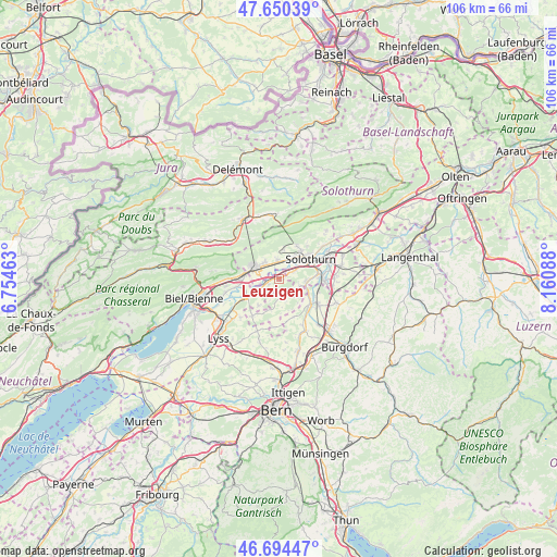
Leuzigen GPS coordinates[2]
47° 10' 28.488" North, 7° 27' 27.9" East
| Map corner | latitude | longitude |
|---|---|---|
| Upper-left | 47.65039°, | 6.75463° |
| Center: | 47.17458°, | 7.45775° |
| Lower-right: | 46.69447°, | 8.16088° |
| Map W x H: | 106.3×106.3 km | = 66.1×66.1mi |
| max Lat: | 47.76737° ⇑54.7% North |
| Leuzigen: | 47.17458° |
| min Lat: | ⇓45.3% South 45.83203° |
| min Long | Leuzigen | max Long |
| 5.97153° | 7.45775° | 10.44624° |
| W 23.4%⇐ | ⇒76.6% E |
Elevation
Elevation of Leuzigen is 455 m = 1493 ft, and this is 103.2 m = 339 ft below average elevation for this country.
| Max E: |
1845 m = 6053 ft | 59.8% |
| Avg. | 558.2 m = 1831 ft | |
| Leuzigen | 455 m = 1493 ft | |
Min E: |
197 m = 646 ft | 40.2% |
See also: Switzerland elevation on elevation.city.
Geographical zone
Leuzigen is located in North temperate zone (between Tropic of Cancer and the Arctic Circle). Distance of this North polar circle is 2155.9 km =1339.6 mi to North.| Distance of | km | miles | from Leuzigen |
|---|---|---|---|
| North Pole | 4761.7 | 2958.8 | to North |
| Arctic Circle | 2155.9 | 1339.6 | to North |
| Tropic Cancer | 2639.4 | 1640 | to South |
| Equator | 5245.3 | 3259.3 | to South |


Nearby cities:
15 places around Leuzigen: (largest is in red/bold)
• Arch
2.2 km =1.4 mi,  242°
242°
• Bettlach
3.9 km =2.4 mi,  318°
318°
• Biberist
7.9 km =4.9 mi,  85°
85°
• Bätterkinden
7.7 km =4.8 mi,  128°
128°
• Büren an der Aare
7.5 km =4.7 mi, 239°
• Gerlafingen
8.7 km =5.4 mi, 92°
• Grenchen
5.1 km =3.2 mi,  292°
292°
• Langendorf
6.6 km =4.1 mi,  40°
40°
• Lengnau
6.8 km =4.2 mi,  276°
276°
• Meinisberg
8.5 km =5.3 mi,  258°
258°
• Schnottwil
8.5 km =5.3 mi,  214°
214°
• Selzach
3.4 km =2.1 mi,  356°
356°
• Solothurn
7.1 km =4.4 mi,  58°
58°
• Utzenstorf
8.6 km =5.3 mi,  122°
122°
• Zuchwil
8.8 km =5.5 mi,  69°
69°
Sources, notices
• [Note1] Compared only with cities in Switzerland existing in our database
• [Src1] Map data: © OpenStreetMap contributors (CC-BY-SA)
• [Src2] Other city data from geonames.org with taken over terms of usage.
• [Src3] Geographical zone / Annual Mean Temperature by Robert A. Rohde @ Wikipedia
