Grenchen geodata
Grenchen (Solothurn) is a populated place; located in Switzerland in Europe/Zurich (GMT+2) time zone. With population of 15,927 people, there are 71 cities with bigger population in this country. Compared to other cities in Switzerland, 53.4% of cities are located further ↑North; 77.9% of cities are located further →East and 60.3% of cities have higher elevation than Grenchen. Note1


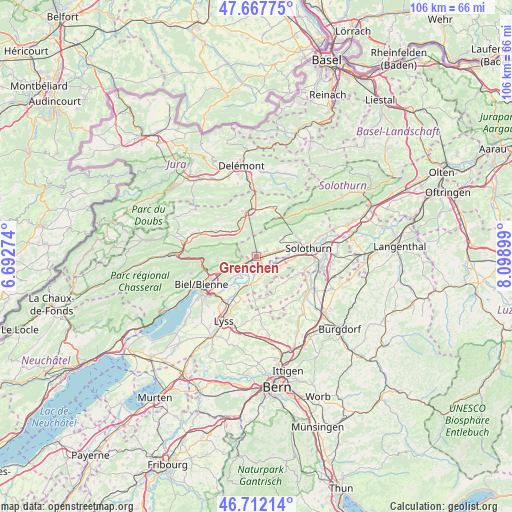
Grenchen GPS coordinates[2]
47° 11' 31.56" North, 7° 23' 45.096" East
| Map corner | latitude | longitude |
|---|---|---|
| Upper-left | 47.66775°, | 6.69274° |
| Center: | 47.1921°, | 7.39586° |
| Lower-right: | 46.71214°, | 8.09899° |
| Map W x H: | 106.3×106.3 km | = 66.1×66.1mi |
| max Lat: | 47.76737° ⇑53.4% North |
| Grenchen: | 47.1921° |
| min Lat: | ⇓46.6% South 45.83203° |
| min Long | Grenchen | max Long |
| 5.97153° | 7.39586° | 10.44624° |
| W 22.1%⇐ | ⇒77.9% E |
Elevation
Elevation of Grenchen is 454 m = 1490 ft, and this is 104.2 m = 342 ft below average elevation for this country.
| Max E: |
1845 m = 6053 ft | 60.3% |
| Avg. | 558.2 m = 1831 ft | |
| Grenchen | 454 m = 1490 ft | |
Min E: |
197 m = 646 ft | 39.7% |
See also: Switzerland elevation on elevation.city.
Geographical zone
Grenchen is located in North temperate zone (between Tropic of Cancer and the Arctic Circle). Distance of this North polar circle is 2153.9 km =1338.4 mi to North.| Distance of | km | miles | from Grenchen |
|---|---|---|---|
| North Pole | 4759.8 | 2957.6 | to North |
| Arctic Circle | 2153.9 | 1338.4 | to North |
| Tropic Cancer | 2641.4 | 1641.3 | to South |
| Equator | 5247.3 | 3260.5 | to South |


Nearby cities:
15 places around Grenchen: (largest is in red/bold)
• Arch
4 km =2.5 mi,  137°
137°
• Bettlach
2.3 km =1.4 mi,  66°
66°
• Bévilard
9.9 km =6.2 mi,  300°
300°
• Büren an der Aare
6 km =3.7 mi,  197°
197°
• Court
6.9 km =4.3 mi,  319°
319°
• Langendorf
9.5 km =5.9 mi, 71°
• Lengnau
2.4 km =1.5 mi,  240°
240°
• Leuzigen
5.1 km =3.2 mi,  112°
112°
• Meinisberg
5.1 km =3.2 mi,  225°
225°
• Moutier
9.8 km =6.1 mi,  348°
348°
• Orpund
8.9 km =5.5 mi, 228°
• Perrefitte
10.2 km =6.3 mi,  336°
336°
• Pieterlen
4.8 km =3 mi,  246°
246°
• Schnottwil
8.9 km =5.5 mi,  181°
181°
• Selzach
4.7 km =2.9 mi, 71°
Sources, notices
• [Note1] Compared only with cities in Switzerland existing in our database
• [Src1] Map data: © OpenStreetMap contributors (CC-BY-SA)
• [Src2] Other city data from geonames.org with taken over terms of usage.
• [Src3] Geographical zone / Annual Mean Temperature by Robert A. Rohde @ Wikipedia
