Sainte-Croix geodata
Sainte-Croix (Vaud) is a populated place; located in Switzerland in Europe/Zurich (GMT+2) time zone. With population of 4,214 people, there are 410 cities with bigger population in this country. Compared to other cities in Switzerland, 73.1% of cities are located further ↑North; 95.4% of cities are located further →East and 96.2% of cities have lower elevation than Sainte-Croix. Note1


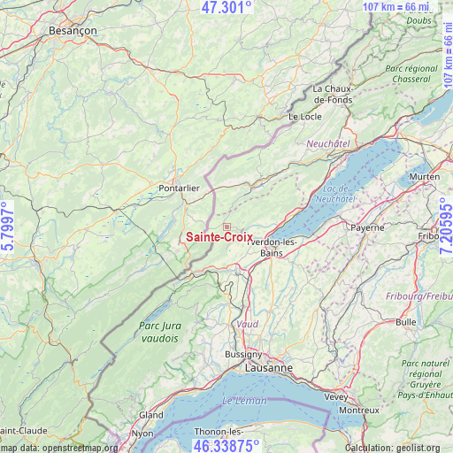
Sainte-Croix GPS coordinates[2]
46° 49' 19.308" North, 6° 30' 10.188" East
| Map corner | latitude | longitude |
|---|---|---|
| Upper-left | 47.301°, | 5.7997° |
| Center: | 46.82203°, | 6.50283° |
| Lower-right: | 46.33875°, | 7.20595° |
| Map W x H: | 107×107 km | = 66.5×66.5mi |
| max Lat: | 47.76737° ⇑73.1% North |
| Sainte-Croix: | 46.82203° |
| min Lat: | ⇓26.9% South 45.83203° |
| min Long | Sainte-Croix | max Long |
| 5.97153° | 6.50283° | 10.44624° |
| W 4.6%⇐ | ⇒95.4% E |
Elevation
Elevation of Sainte-Croix is 1082 m = 3550 ft, and this is 523.8 m = 1719 ft above average elevation for this country.
| Max E: |
1845 m = 6053 ft | 3.8% |
| Sainte-Croix | 1082 m 3550 ft | |
| Avg. | 558.2 m = 1831 ft | |
Min E: |
197 m = 646 ft | 96.2% |
See also: Switzerland elevation on elevation.city.
Geographical zone
Sainte-Croix is located in North temperate zone (between Tropic of Cancer and the Arctic Circle). Distance of this North polar circle is 2195.1 km =1364 mi to North.| Distance of | km | miles | from Sainte-Croix |
|---|---|---|---|
| North Pole | 4800.9 | 2983.1 | to North |
| Arctic Circle | 2195.1 | 1364 | to North |
| Tropic Cancer | 2600.2 | 1615.7 | to South |
| Equator | 5206.1 | 3234.9 | to South |


Nearby cities:
15 places around Sainte-Croix: (largest is in red/bold)
• Baulmes
3.8 km =2.4 mi,  156°
156°
• Bullet
4 km =2.5 mi,  75°
75°
• Buttes
8.2 km =5.1 mi,  26°
26°
• Champagne
12 km =7.5 mi, 84°
• Fleurier
10.8 km =6.7 mi, 34°
• Grandson
11 km =6.8 mi,  97°
97°
• La Côte-aux-Fées
5.1 km =3.2 mi,  349°
349°
• Les Clées
10.5 km =6.5 mi,  197°
197°
• Les Verrières
9.3 km =5.8 mi, 349°
• Montagny
8.9 km =5.5 mi,  111°
111°
• Orbe
11 km =6.8 mi,  168°
168°
• Saint-Sulpice
10.9 km =6.8 mi,  24°
24°
• Valeyres-sous-Montagny
8.6 km =5.3 mi, 107°
• Villars-Burquin
9.9 km =6.2 mi,  72°
72°
• Yverdon-les-Bains
11.6 km =7.2 mi, 114°
Sources, notices
• [Note1] Compared only with cities in Switzerland existing in our database
• [Src1] Map data: © OpenStreetMap contributors (CC-BY-SA)
• [Src2] Other city data from geonames.org with taken over terms of usage.
• [Src3] Geographical zone / Annual Mean Temperature by Robert A. Rohde @ Wikipedia
