Schmerikon geodata
Schmerikon (Saint Gallen) is a seat of a third-order administrative division; located in Switzerland in Europe/Zurich (GMT+2) time zone. With population of 3,307 people, there are 527 cities with bigger population in this country. Compared to other cities in Switzerland, 50.6% of cities are located further ↑North; 86.1% of cities are located further ←West and 86.2% of cities have higher elevation than Schmerikon. Note1


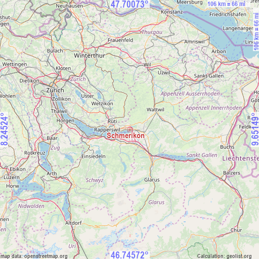
Schmerikon GPS coordinates[2]
47° 13' 31.368" North, 8° 56' 54.096" East
| Map corner | latitude | longitude |
|---|---|---|
| Upper-left | 47.70073°, | 8.24524° |
| Center: | 47.22538°, | 8.94836° |
| Lower-right: | 46.74572°, | 9.65149° |
| Map W x H: | 106.2×106.2 km | = 66×66mi |
| max Lat: | 47.76737° ⇑50.6% North |
| Schmerikon: | 47.22538° |
| min Lat: | ⇓49.4% South 45.83203° |
| min Long | Schmerikon | max Long |
| 5.97153° | 8.94836° | 10.44624° |
| W 86.1%⇐ | ⇒13.9% E |
Elevation
Elevation of Schmerikon is 407 m = 1335 ft, and this is 151.2 m = 496 ft below average elevation for this country.
| Max E: |
1845 m = 6053 ft | 86.2% |
| Avg. | 558.2 m = 1831 ft | |
| Schmerikon | 407 m = 1335 ft | |
Min E: |
197 m = 646 ft | 13.8% |
See also: Switzerland elevation on elevation.city.
Geographical zone
Schmerikon is located in North temperate zone (between Tropic of Cancer and the Arctic Circle). Distance of this North polar circle is 2150.2 km =1336.1 mi to North.| Distance of | km | miles | from Schmerikon |
|---|---|---|---|
| North Pole | 4756.1 | 2955.3 | to North |
| Arctic Circle | 2150.2 | 1336.1 | to North |
| Tropic Cancer | 2645.1 | 1643.6 | to South |
| Equator | 5251 | 3262.8 | to South |


Nearby cities:
15 places around Schmerikon: (largest is in red/bold)
• Benken
5.3 km =3.3 mi,  122°
122°
• Eschenbach
2.6 km =1.6 mi,  308°
308°
• Goldingen
4.5 km =2.8 mi,  12°
12°
• Gommiswald
5.7 km =3.5 mi,  83°
83°
• Kaltbrunn
6 km =3.7 mi,  102°
102°
• Laupen
4.7 km =2.9 mi,  341°
341°
• Reichenburg
6.4 km =4 mi,  160°
160°
• Rüti / Dorfzentrum, Südl. Teil
7.6 km =4.7 mi,  294°
294°
• Rüti / Oberdorf
7.3 km =4.5 mi,  300°
300°
• Sankt Gallenkappel
2.4 km =1.5 mi,  30°
30°
• Schübelbach
6 km =3.7 mi,  194°
194°
• Siebnen
6.8 km =4.2 mi,  214°
214°
• Tuggen
2.5 km =1.6 mi,  178°
178°
• Uznach
2.6 km =1.6 mi,  92°
92°
• Wald
6.2 km =3.9 mi, 335°
Sources, notices
• [Note1] Compared only with cities in Switzerland existing in our database
• [Src1] Map data: © OpenStreetMap contributors (CC-BY-SA)
• [Src2] Other city data from geonames.org with taken over terms of usage.
• [Src3] Geographical zone / Annual Mean Temperature by Robert A. Rohde @ Wikipedia
