Alterswil geodata
Alterswil (Fribourg) is a populated place; located in Switzerland in Europe/Zurich (GMT+2) time zone. With population of 1,850 people, there are 887 cities with bigger population in this country. Compared to other cities in Switzerland, 74.7% of cities are located further ↑North; 80.6% of cities are located further →East and 86.5% of cities have lower elevation than Alterswil. Note1


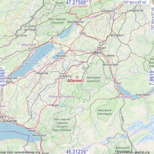
Alterswil GPS coordinates[2]
46° 47' 45.132" North, 7° 15' 31.572" East
| Map corner | latitude | longitude |
|---|---|---|
| Upper-left | 47.27508°, | 6.55565° |
| Center: | 46.79587°, | 7.25877° |
| Lower-right: | 46.31236°, | 7.9619° |
| Map W x H: | 107×107 km | = 66.5×66.5mi |
| max Lat: | 47.76737° ⇑74.7% North |
| Alterswil: | 46.79587° |
| min Lat: | ⇓25.3% South 45.83203° |
| min Long | Alterswil | max Long |
| 5.97153° | 7.25877° | 10.44624° |
| W 19.4%⇐ | ⇒80.6% E |
Elevation
Elevation of Alterswil is 757 m = 2484 ft, and this is 198.8 m = 652 ft above average elevation for this country.
| Max E: |
1845 m = 6053 ft | 13.5% |
| Alterswil | 757 m 2484 ft | |
| Avg. | 558.2 m = 1831 ft | |
Min E: |
197 m = 646 ft | 86.5% |
See also: Switzerland elevation on elevation.city.
Geographical zone
Alterswil is located in North temperate zone (between Tropic of Cancer and the Arctic Circle). Distance of this North polar circle is 2198 km =1365.8 mi to North.| Distance of | km | miles | from Alterswil |
|---|---|---|---|
| North Pole | 4803.8 | 2984.9 | to North |
| Arctic Circle | 2198 | 1365.8 | to North |
| Tropic Cancer | 2597.3 | 1613.9 | to South |
| Equator | 5203.2 | 3233.1 | to South |


Nearby cities:
15 places around Alterswil: (largest is in red/bold)
• Düdingen
7.8 km =4.8 mi,  319°
319°
• Fribourg
8.2 km =5.1 mi,  275°
275°
• Giffers
5.3 km =3.3 mi,  225°
225°
• Guggisberg
6.2 km =3.9 mi,  120°
120°
• Heitenried
4.7 km =2.9 mi,  41°
41°
• Marly
7.5 km =4.7 mi,  252°
252°
• Oberschrot
6.3 km =3.9 mi,  164°
164°
• Plaffeien
6.4 km =4 mi, 160°
• Plasselb
6.8 km =4.2 mi,  184°
184°
• Praroman
7.9 km =4.9 mi, 231°
• Rechthalten
3.4 km =2.1 mi,  204°
204°
• Sankt Antoni
2.9 km =1.8 mi,  3°
3°
• Schmitten
6.9 km =4.3 mi,  354°
354°
• Tafers
3.7 km =2.3 mi,  304°
304°
• Ueberstorf
8.7 km =5.4 mi,  26°
26°
Sources, notices
• [Note1] Compared only with cities in Switzerland existing in our database
• [Src1] Map data: © OpenStreetMap contributors (CC-BY-SA)
• [Src2] Other city data from geonames.org with taken over terms of usage.
• [Src3] Geographical zone / Annual Mean Temperature by Robert A. Rohde @ Wikipedia
