Sankt Antoni geodata
Sankt Antoni (Fribourg) is a populated place; located in Switzerland in Europe/Zurich (GMT+2) time zone. With population of 1,849 people, there are 888 cities with bigger population in this country. Compared to other cities in Switzerland, 73.1% of cities are located further ↑North; 80.4% of cities are located further →East and 83.7% of cities have lower elevation than Sankt Antoni. Note1


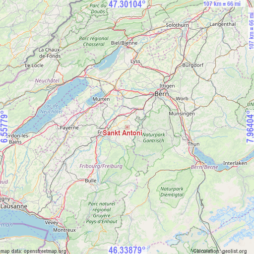
Sankt Antoni GPS coordinates[2]
46° 49' 19.452" North, 7° 15' 39.276" East
| Map corner | latitude | longitude |
|---|---|---|
| Upper-left | 47.30104°, | 6.55779° |
| Center: | 46.82207°, | 7.26091° |
| Lower-right: | 46.33879°, | 7.96404° |
| Map W x H: | 107×107 km | = 66.5×66.5mi |
| max Lat: | 47.76737° ⇑73.1% North |
| Sankt Antoni: | 46.82207° |
| min Lat: | ⇓26.9% South 45.83203° |
| min Long | Sankt Antoni | max Long |
| 5.97153° | 7.26091° | 10.44624° |
| W 19.6%⇐ | ⇒80.4% E |
Elevation
Elevation of Sankt Antoni is 718 m = 2356 ft, and this is 159.8 m = 524 ft above average elevation for this country.
| Max E: |
1845 m = 6053 ft | 16.3% |
| Sankt Antoni | 718 m 2356 ft | |
| Avg. | 558.2 m = 1831 ft | |
Min E: |
197 m = 646 ft | 83.7% |
See also: Switzerland elevation on elevation.city.
Geographical zone
Sankt Antoni is located in North temperate zone (between Tropic of Cancer and the Arctic Circle). Distance of this North polar circle is 2195 km =1363.9 mi to North.| Distance of | km | miles | from Sankt Antoni |
|---|---|---|---|
| North Pole | 4800.9 | 2983.1 | to North |
| Arctic Circle | 2195 | 1363.9 | to North |
| Tropic Cancer | 2600.2 | 1615.7 | to South |
| Equator | 5206.1 | 3234.9 | to South |


Nearby cities:
15 places around Sankt Antoni: (largest is in red/bold)
• Alterswil
2.9 km =1.8 mi,  183°
183°
• Barberêche
8.7 km =5.4 mi,  296°
296°
• Bösingen
8.2 km =5.1 mi,  342°
342°
• Düdingen
6.1 km =3.8 mi, 299°
• Flamatt
8.9 km =5.5 mi,  31°
31°
• Fribourg
8.6 km =5.3 mi,  255°
255°
• Giffers
7.8 km =4.8 mi,  211°
211°
• Guggisberg
8 km =5 mi,  139°
139°
• Heitenried
3 km =1.9 mi,  78°
78°
• Laupen
9 km =5.6 mi,  349°
349°
• Marly
8.9 km =5.5 mi,  235°
235°
• Rechthalten
6.3 km =3.9 mi,  194°
194°
• Schmitten
4 km =2.5 mi, 348°
• Tafers
3.3 km =2.1 mi, 255°
• Ueberstorf
6.1 km =3.8 mi,  37°
37°
Sources, notices
• [Note1] Compared only with cities in Switzerland existing in our database
• [Src1] Map data: © OpenStreetMap contributors (CC-BY-SA)
• [Src2] Other city data from geonames.org with taken over terms of usage.
• [Src3] Geographical zone / Annual Mean Temperature by Robert A. Rohde @ Wikipedia
