Tafers geodata
Tafers (Fribourg) is a seat of a second-order administrative division; located in Switzerland in Europe/Zurich (GMT+2) time zone. With population of 2,833 people, there are 620 cities with bigger population in this country. Compared to other cities in Switzerland, 73.6% of cities are located further ↑North; 81.6% of cities are located further →East and 80.1% of cities have lower elevation than Tafers. Note1


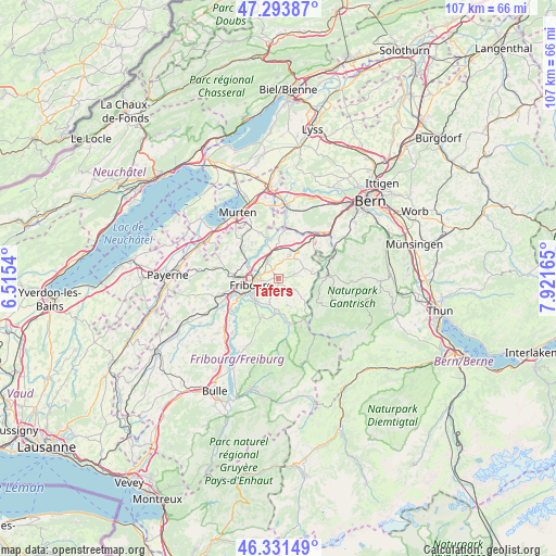
Tafers GPS coordinates[2]
46° 48' 53.388" North, 7° 13' 6.672" East
| Map corner | latitude | longitude |
|---|---|---|
| Upper-left | 47.29387°, | 6.5154° |
| Center: | 46.81483°, | 7.21852° |
| Lower-right: | 46.33149°, | 7.92165° |
| Map W x H: | 107×107 km | = 66.5×66.5mi |
| max Lat: | 47.76737° ⇑73.6% North |
| Tafers: | 46.81483° |
| min Lat: | ⇓26.4% South 45.83203° |
| min Long | Tafers | max Long |
| 5.97153° | 7.21852° | 10.44624° |
| W 18.4%⇐ | ⇒81.6% E |
Elevation
Elevation of Tafers is 661 m = 2169 ft, and this is 102.8 m = 337 ft above average elevation for this country.
| Max E: |
1845 m = 6053 ft | 19.9% |
| Tafers | 661 m 2169 ft | |
| Avg. | 558.2 m = 1831 ft | |
Min E: |
197 m = 646 ft | 80.1% |
See also: Switzerland elevation on elevation.city.
Geographical zone
Tafers is located in North temperate zone (between Tropic of Cancer and the Arctic Circle). Distance of this North polar circle is 2195.9 km =1364.5 mi to North.| Distance of | km | miles | from Tafers |
|---|---|---|---|
| North Pole | 4801.7 | 2983.6 | to North |
| Arctic Circle | 2195.9 | 1364.5 | to North |
| Tropic Cancer | 2599.4 | 1615.2 | to South |
| Equator | 5205.3 | 3234.4 | to South |


Nearby cities:
15 places around Tafers: (largest is in red/bold)
• Alterswil
3.7 km =2.3 mi,  124°
124°
• Barberêche
6.6 km =4.1 mi,  316°
316°
• Belfaux
8.5 km =5.3 mi,  275°
275°
• Cordast
8.5 km =5.3 mi, 323°
• Düdingen
4.3 km =2.7 mi,  331°
331°
• Fribourg
5.3 km =3.3 mi,  254°
254°
• Giffers
5.9 km =3.7 mi,  187°
187°
• Givisiez
7 km =4.3 mi,  267°
267°
• Heitenried
6.3 km =3.9 mi,  76°
76°
• Marly
5.9 km =3.7 mi,  223°
223°
• Praroman
7.7 km =4.8 mi,  203°
203°
• Rechthalten
5.5 km =3.4 mi,  162°
162°
• Sankt Antoni
3.3 km =2.1 mi, 75°
• Schmitten
5.3 km =3.3 mi,  27°
27°
• Villars-sur-Glâne
8.2 km =5.1 mi, 250°
Sources, notices
• [Note1] Compared only with cities in Switzerland existing in our database
• [Src1] Map data: © OpenStreetMap contributors (CC-BY-SA)
• [Src2] Other city data from geonames.org with taken over terms of usage.
• [Src3] Geographical zone / Annual Mean Temperature by Robert A. Rohde @ Wikipedia
