Heitenried geodata
Heitenried (Fribourg) is a populated place; located in Switzerland in Europe/Zurich (GMT+2) time zone. With population of 1,106 people, there are 1263 cities with bigger population in this country. Compared to other cities in Switzerland, 73% of cities are located further ↑North; 79.7% of cities are located further →East and 87.3% of cities have lower elevation than Heitenried. Note1


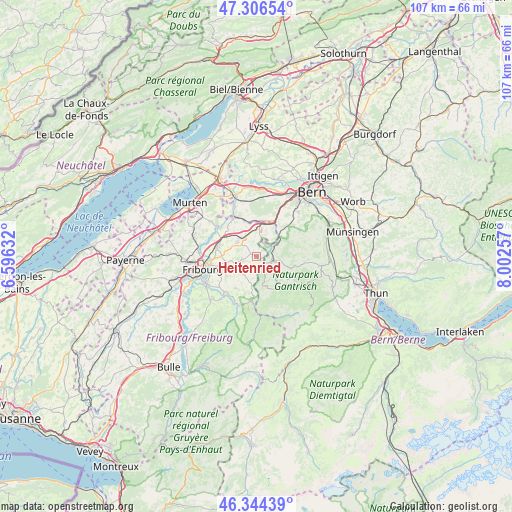
Heitenried GPS coordinates[2]
46° 49' 39.432" North, 7° 17' 57.984" East
| Map corner | latitude | longitude |
|---|---|---|
| Upper-left | 47.30654°, | 6.59632° |
| Center: | 46.82762°, | 7.29944° |
| Lower-right: | 46.34439°, | 8.00257° |
| Map W x H: | 107×107 km | = 66.5×66.5mi |
| max Lat: | 47.76737° ⇑73% North |
| Heitenried: | 46.82762° |
| min Lat: | ⇓27% South 45.83203° |
| min Long | Heitenried | max Long |
| 5.97153° | 7.29944° | 10.44624° |
| W 20.3%⇐ | ⇒79.7% E |
Elevation
Elevation of Heitenried is 768 m = 2520 ft, and this is 209.8 m = 688 ft above average elevation for this country.
| Max E: |
1845 m = 6053 ft | 12.7% |
| Heitenried | 768 m 2520 ft | |
| Avg. | 558.2 m = 1831 ft | |
Min E: |
197 m = 646 ft | 87.3% |
See also: Switzerland elevation on elevation.city.
Geographical zone
Heitenried is located in North temperate zone (between Tropic of Cancer and the Arctic Circle). Distance of this North polar circle is 2194.4 km =1363.5 mi to North.| Distance of | km | miles | from Heitenried |
|---|---|---|---|
| North Pole | 4800.3 | 2982.8 | to North |
| Arctic Circle | 2194.4 | 1363.5 | to North |
| Tropic Cancer | 2600.8 | 1616.1 | to South |
| Equator | 5206.7 | 3235.3 | to South |


Nearby cities:
15 places around Heitenried: (largest is in red/bold)
• Alterswil
4.7 km =2.9 mi,  221°
221°
• Bösingen
9 km =5.6 mi,  322°
322°
• Düdingen
8.6 km =5.3 mi,  286°
286°
• Flamatt
7.1 km =4.4 mi,  13°
13°
• Guggisberg
7.1 km =4.4 mi,  161°
161°
• Laupen
9.4 km =5.8 mi,  331°
331°
• Oberbalm
9.4 km =5.8 mi,  56°
56°
• Oberschrot
9.7 km =6 mi,  188°
188°
• Plaffeien
9.6 km =6 mi, 185°
• Rechthalten
8 km =5 mi,  214°
214°
• Rüschegg
8.8 km =5.5 mi,  127°
127°
• Sankt Antoni
3 km =1.9 mi,  258°
258°
• Schmitten
5 km =3.1 mi,  311°
311°
• Tafers
6.3 km =3.9 mi, 256°
• Ueberstorf
4.3 km =2.7 mi, 10°
Sources, notices
• [Note1] Compared only with cities in Switzerland existing in our database
• [Src1] Map data: © OpenStreetMap contributors (CC-BY-SA)
• [Src2] Other city data from geonames.org with taken over terms of usage.
• [Src3] Geographical zone / Annual Mean Temperature by Robert A. Rohde @ Wikipedia
