Oensingen geodata
Oensingen (Solothurn) is a populated place; located in Switzerland in Europe/Zurich (GMT+2) time zone. With population of 4,609 people, there are 376 cities with bigger population in this country. Compared to other cities in Switzerland, 56.7% of cities are located further ↓South; 68% of cities are located further →East and 59.8% of cities have higher elevation than Oensingen. Note1


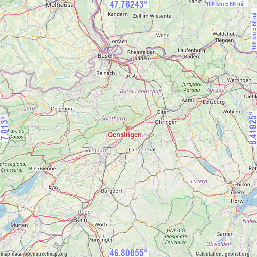
Oensingen GPS coordinates[2]
47° 17' 15.504" North, 7° 42' 58.032" East
| Map corner | latitude | longitude |
|---|---|---|
| Upper-left | 47.76243°, | 7.013° |
| Center: | 47.28764°, | 7.71612° |
| Lower-right: | 46.80855°, | 8.41925° |
| Map W x H: | 106.1×106.1 km | = 65.9×65.9mi |
| max Lat: | 47.76737° ⇑43.3% North |
| Oensingen: | 47.28764° |
| min Lat: | ⇓56.7% South 45.83203° |
| min Long | Oensingen | max Long |
| 5.97153° | 7.71612° | 10.44624° |
| W 32%⇐ | ⇒68% E |
Elevation
Elevation of Oensingen is 455 m = 1493 ft, and this is 103.2 m = 339 ft below average elevation for this country.
| Max E: |
1845 m = 6053 ft | 59.8% |
| Avg. | 558.2 m = 1831 ft | |
| Oensingen | 455 m = 1493 ft | |
Min E: |
197 m = 646 ft | 40.2% |
See also: Switzerland elevation on elevation.city.
Geographical zone
Oensingen is located in North temperate zone (between Tropic of Cancer and the Arctic Circle). Distance of this North polar circle is 2143.3 km =1331.8 mi to North.| Distance of | km | miles | from Oensingen |
|---|---|---|---|
| North Pole | 4749.2 | 2951 | to North |
| Arctic Circle | 2143.3 | 1331.8 | to North |
| Tropic Cancer | 2652 | 1647.9 | to South |
| Equator | 5257.9 | 3267.1 | to South |


Nearby cities:
15 places around Oensingen: (largest is in red/bold)
• Aarwangen
6.7 km =4.2 mi,  144°
144°
• Balsthal
3.6 km =2.2 mi,  331°
331°
• Bannwil
5.5 km =3.4 mi,  164°
164°
• Egerkingen
6.2 km =3.9 mi,  55°
55°
• Holderbank
5.8 km =3.6 mi,  28°
28°
• Laupersdorf
5.4 km =3.4 mi,  300°
300°
• Matzendorf
6.9 km =4.3 mi,  285°
285°
• Niederbipp
2.3 km =1.4 mi,  220°
220°
• Niederbuchsiten
4.3 km =2.7 mi,  76°
76°
• Oberbipp
5 km =3.1 mi,  232°
232°
• Oberbuchsiten
4.9 km =3 mi,  54°
54°
• Walliswil bei Niederbipp
6 km =3.7 mi,  199°
199°
• Wangen an der Aare
7.8 km =4.8 mi, 217°
• Wiedlisbach
6.6 km =4.1 mi, 233°
• Wolfwil
6.4 km =4 mi,  109°
109°
Sources, notices
• [Note1] Compared only with cities in Switzerland existing in our database
• [Src1] Map data: © OpenStreetMap contributors (CC-BY-SA)
• [Src2] Other city data from geonames.org with taken over terms of usage.
• [Src3] Geographical zone / Annual Mean Temperature by Robert A. Rohde @ Wikipedia
