Niederbuchsiten geodata
Niederbuchsiten (Solothurn) is a populated place; located in Switzerland in Europe/Zurich (GMT+2) time zone. With population of 947 people, there are 1375 cities with bigger population in this country. Compared to other cities in Switzerland, 57.6% of cities are located further ↓South; 66.5% of cities are located further →East and 66.6% of cities have higher elevation than Niederbuchsiten. Note1


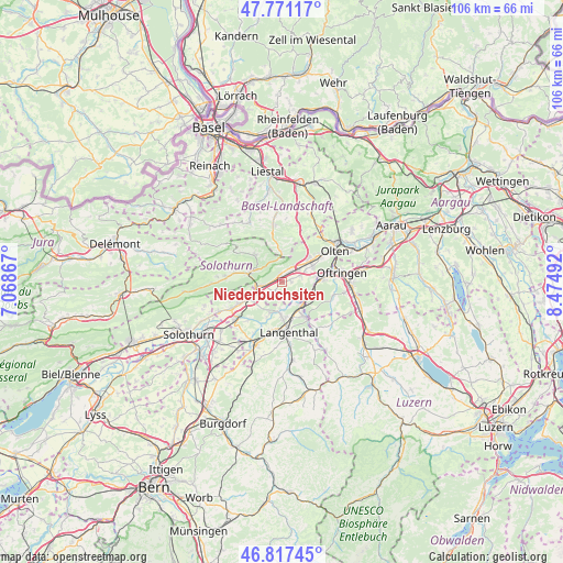
Niederbuchsiten GPS coordinates[2]
47° 17' 47.256" North, 7° 46' 18.48" East
| Map corner | latitude | longitude |
|---|---|---|
| Upper-left | 47.77117°, | 7.06867° |
| Center: | 47.29646°, | 7.7718° |
| Lower-right: | 46.81745°, | 8.47492° |
| Map W x H: | 106×106 km | = 65.9×65.9mi |
| max Lat: | 47.76737° ⇑42.4% North |
| Niederbuchsiten: | 47.29646° |
| min Lat: | ⇓57.6% South 45.83203° |
| min Long | Niederbuchsiten | max Long |
| 5.97153° | 7.7718° | 10.44624° |
| W 33.5%⇐ | ⇒66.5% E |
Elevation
Elevation of Niederbuchsiten is 443 m = 1453 ft, and this is 115.2 m = 378 ft below average elevation for this country.
| Max E: |
1845 m = 6053 ft | 66.6% |
| Avg. | 558.2 m = 1831 ft | |
| Niederbuchsiten | 443 m = 1453 ft | |
Min E: |
197 m = 646 ft | 33.4% |
See also: Switzerland elevation on elevation.city.
Geographical zone
Niederbuchsiten is located in North temperate zone (between Tropic of Cancer and the Arctic Circle). Distance of this North polar circle is 2142.3 km =1331.2 mi to North.| Distance of | km | miles | from Niederbuchsiten |
|---|---|---|---|
| North Pole | 4748.2 | 2950.4 | to North |
| Arctic Circle | 2142.3 | 1331.2 | to North |
| Tropic Cancer | 2653 | 1648.5 | to South |
| Equator | 5258.9 | 3267.7 | to South |


Nearby cities:
15 places around Niederbuchsiten: (largest is in red/bold)
• Aarwangen
6.5 km =4 mi,  182°
182°
• Balsthal
6.3 km =3.9 mi,  290°
290°
• Bannwil
6.8 km =4.2 mi,  203°
203°
• Egerkingen
2.7 km =1.7 mi,  20°
20°
• Fulenbach
5.3 km =3.3 mi,  122°
122°
• Gunzgen
4.9 km =3 mi,  66°
66°
• Holderbank
4.3 km =2.7 mi,  340°
340°
• Hägendorf
6.8 km =4.2 mi,  50°
50°
• Langenbruck
5.9 km =3.7 mi,  357°
357°
• Murgenthal
5.8 km =3.6 mi, 118°
• Niederbipp
6.4 km =4 mi,  244°
244°
• Oberbuchsiten
1.9 km =1.2 mi,  352°
352°
• Oensingen
4.3 km =2.7 mi,  256°
256°
• Wolfwil
3.6 km =2.2 mi,  148°
148°
• Wynau
5.6 km =3.5 mi,  143°
143°
Sources, notices
• [Note1] Compared only with cities in Switzerland existing in our database
• [Src1] Map data: © OpenStreetMap contributors (CC-BY-SA)
• [Src2] Other city data from geonames.org with taken over terms of usage.
• [Src3] Geographical zone / Annual Mean Temperature by Robert A. Rohde @ Wikipedia
