Wolfwil geodata
Wolfwil (Solothurn) is a populated place; located in Switzerland in Europe/Zurich (GMT+2) time zone. With population of 2,079 people, there are 814 cities with bigger population in this country. Compared to other cities in Switzerland, 54.1% of cities are located further ↓South; 65.6% of cities are located further →East and 82.2% of cities have higher elevation than Wolfwil. Note1


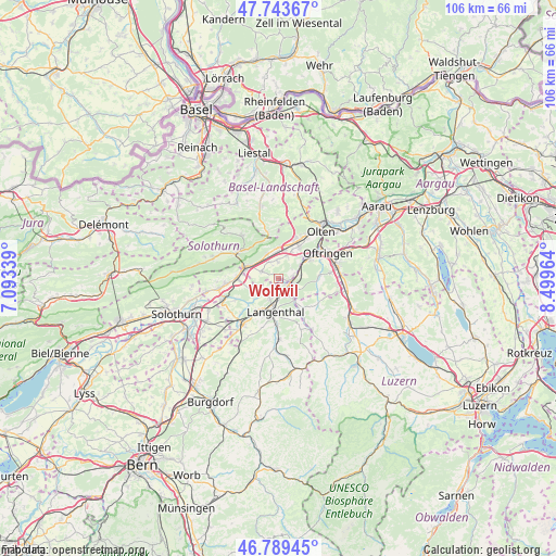
Wolfwil GPS coordinates[2]
47° 16' 7.356" North, 7° 47' 47.472" East
| Map corner | latitude | longitude |
|---|---|---|
| Upper-left | 47.74367°, | 7.09339° |
| Center: | 47.26871°, | 7.79652° |
| Lower-right: | 46.78945°, | 8.49964° |
| Map W x H: | 106.1×106.1 km | = 65.9×65.9mi |
| max Lat: | 47.76737° ⇑45.9% North |
| Wolfwil: | 47.26871° |
| min Lat: | ⇓54.1% South 45.83203° |
| min Long | Wolfwil | max Long |
| 5.97153° | 7.79652° | 10.44624° |
| W 34.4%⇐ | ⇒65.6% E |
Elevation
Elevation of Wolfwil is 417 m = 1368 ft, and this is 141.2 m = 463 ft below average elevation for this country.
| Max E: |
1845 m = 6053 ft | 82.2% |
| Avg. | 558.2 m = 1831 ft | |
| Wolfwil | 417 m = 1368 ft | |
Min E: |
197 m = 646 ft | 17.8% |
See also: Switzerland elevation on elevation.city.
Geographical zone
Wolfwil is located in North temperate zone (between Tropic of Cancer and the Arctic Circle). Distance of this North polar circle is 2145.4 km =1333.1 mi to North.| Distance of | km | miles | from Wolfwil |
|---|---|---|---|
| North Pole | 4751.3 | 2952.3 | to North |
| Arctic Circle | 2145.4 | 1333.1 | to North |
| Tropic Cancer | 2649.9 | 1646.6 | to South |
| Equator | 5255.8 | 3265.8 | to South |


Nearby cities:
15 places around Wolfwil: (largest is in red/bold)
• Aarwangen
4 km =2.5 mi,  212°
212°
• Bannwil
5.6 km =3.5 mi,  235°
235°
• Egerkingen
5.7 km =3.5 mi,  350°
350°
• Fulenbach
2.6 km =1.6 mi,  84°
84°
• Gunzgen
5.6 km =3.5 mi,  27°
27°
• Holderbank
7.9 km =4.9 mi,  335°
335°
• Langenthal
5.9 km =3.7 mi,  180°
180°
• Murgenthal
3.2 km =2 mi, 84°
• Niederbipp
7.6 km =4.7 mi,  272°
272°
• Niederbuchsiten
3.6 km =2.2 mi,  328°
328°
• Oberbuchsiten
5.4 km =3.4 mi, 336°
• Oensingen
6.4 km =4 mi,  289°
289°
• Roggwil
3.6 km =2.2 mi,  148°
148°
• Vordemwald
7.9 km =4.9 mi, 84°
• Wynau
2.1 km =1.3 mi,  134°
134°
Sources, notices
• [Note1] Compared only with cities in Switzerland existing in our database
• [Src1] Map data: © OpenStreetMap contributors (CC-BY-SA)
• [Src2] Other city data from geonames.org with taken over terms of usage.
• [Src3] Geographical zone / Annual Mean Temperature by Robert A. Rohde @ Wikipedia
