Balsthal geodata
Balsthal (Solothurn) is a populated place; located in Switzerland in Europe/Zurich (GMT+2) time zone. With population of 5,863 people, there are 283 cities with bigger population in this country. Compared to other cities in Switzerland, 60.3% of cities are located further ↓South; 68.5% of cities are located further →East and 54.6% of cities have lower elevation than Balsthal. Note1


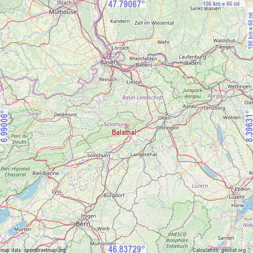
Balsthal GPS coordinates[2]
47° 18' 58.068" North, 7° 41' 35.448" East
| Map corner | latitude | longitude |
|---|---|---|
| Upper-left | 47.79067°, | 6.99006° |
| Center: | 47.31613°, | 7.69318° |
| Lower-right: | 46.83729°, | 8.39631° |
| Map W x H: | 106×106 km | = 65.9×65.9mi |
| max Lat: | 47.76737° ⇑39.7% North |
| Balsthal: | 47.31613° |
| min Lat: | ⇓60.3% South 45.83203° |
| min Long | Balsthal | max Long |
| 5.97153° | 7.69318° | 10.44624° |
| W 31.5%⇐ | ⇒68.5% E |
Elevation
Elevation of Balsthal is 493 m = 1617 ft, and this is 65.2 m = 214 ft below average elevation for this country.
| Max E: |
1845 m = 6053 ft | 45.4% |
| Avg. | 558.2 m = 1831 ft | |
| Balsthal | 493 m = 1617 ft | |
Min E: |
197 m = 646 ft | 54.6% |
See also: Switzerland elevation on elevation.city.
Geographical zone
Balsthal is located in North temperate zone (between Tropic of Cancer and the Arctic Circle). Distance of this North polar circle is 2140.1 km =1329.8 mi to North.| Distance of | km | miles | from Balsthal |
|---|---|---|---|
| North Pole | 4746 | 2949 | to North |
| Arctic Circle | 2140.1 | 1329.8 | to North |
| Tropic Cancer | 2655.1 | 1649.8 | to South |
| Equator | 5261.1 | 3269.1 | to South |


Nearby cities:
15 places around Balsthal: (largest is in red/bold)
• Aedermannsdorf
6.4 km =4 mi,  257°
257°
• Egerkingen
6.9 km =4.3 mi,  86°
86°
• Herbetswil
7.9 km =4.9 mi,  253°
253°
• Holderbank
4.9 km =3 mi,  67°
67°
• Langenbruck
6.7 km =4.2 mi,  56°
56°
• Laupersdorf
2.9 km =1.8 mi, 262°
• Matzendorf
5.1 km =3.2 mi, 254°
• Niederbipp
4.9 km =3 mi,  177°
177°
• Niederbuchsiten
6.3 km =3.9 mi,  110°
110°
• Oberbipp
6.6 km =4.1 mi,  199°
199°
• Oberbuchsiten
5.7 km =3.5 mi, 93°
• Oensingen
3.6 km =2.2 mi,  151°
151°
• Waldenburg
8.6 km =5.3 mi,  29°
29°
• Walliswil bei Niederbipp
8.9 km =5.5 mi, 181°
• Wiedlisbach
8 km =5 mi,  206°
206°
Sources, notices
• [Note1] Compared only with cities in Switzerland existing in our database
• [Src1] Map data: © OpenStreetMap contributors (CC-BY-SA)
• [Src2] Other city data from geonames.org with taken over terms of usage.
• [Src3] Geographical zone / Annual Mean Temperature by Robert A. Rohde @ Wikipedia
