Walliswil bei Niederbipp geodata
Walliswil bei Niederbipp (Bern) is a seat of a third-order administrative division; located in Switzerland in Europe/Zurich (GMT+2) time zone. In our database, there are 1823 cities with bigger population. Compared to other cities in Switzerland, 50.3% of cities are located further ↓South; 68.7% of cities are located further →East and 65.3% of cities have higher elevation than Walliswil bei Niederbipp. Note1
Current local time in Walliswil bei Niederbipp:
07:37 AM, SaturdayDifference from your time zone: hours


Walliswil bei Niederbipp GPS coordinates[2]
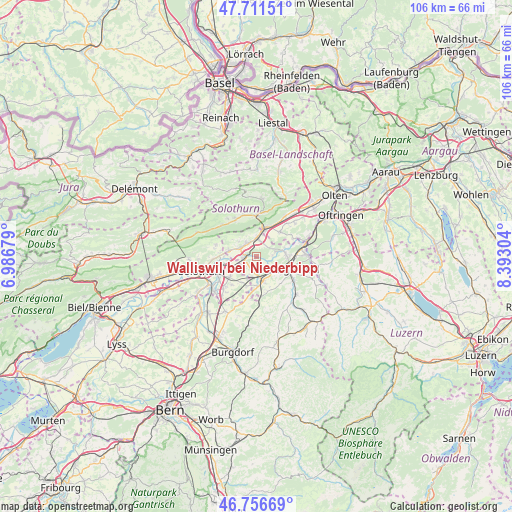
47° 14' 10.5" North, 7° 41' 23.676" East
| Map corner | latitude | longitude |
|---|---|---|
| Upper-left | 47.71151°, | 6.98679° |
| Center: | 47.23625°, | 7.68991° |
| Lower-right: | 46.75669°, | 8.39304° |
| Map W x H: | 106.2×106.2 km | = 66×66mi |
| max Lat: | 47.76737° ⇑49.7% North |
| Walliswil bei Niederbipp: | 47.23625° |
| min Lat: | ⇓50.3% South 45.83203° |
| min Long | Walliswil bei N | max Long |
| 5.97153° | 7.68991° | 10.44624° |
| W 31.3%⇐ | ⇒68.7% E |
Elevation
Elevation of Walliswil bei Niederbipp is 446 m = 1463 ft, and this is 112.2 m = 368 ft below average elevation for this country.
| Max E: |
1845 m = 6053 ft | 65.3% |
| Avg. | 558.2 m = 1831 ft | |
| Walliswil bei Niederbipp | 446 m = 1463 ft | |
Min E: |
197 m = 646 ft | 34.7% |
See also: Switzerland elevation on elevation.city.
Geographical zone
Walliswil bei Niederbipp is located in North temperate zone (between Tropic of Cancer and the Arctic Circle). Distance of this North polar circle is 2149 km =1335.3 mi to North.| Distance of | km | miles | from Walliswil bei Niederbipp |
|---|---|---|---|
| North Pole | 4754.9 | 2954.6 | to North |
| Arctic Circle | 2149 | 1335.3 | to North |
| Tropic Cancer | 2646.3 | 1644.3 | to South |
| Equator | 5252.2 | 3263.6 | to South |


Nearby cities:
15 places around Walliswil bei Niederbipp: (largest is in red/bold)
• Aarwangen
5.9 km =3.7 mi,  87°
87°
• Attiswil
5.9 km =3.7 mi,  281°
281°
• Bannwil
3.5 km =2.2 mi,  83°
83°
• Deitingen
5.9 km =3.7 mi,  246°
246°
• Derendingen
8.7 km =5.4 mi,  241°
241°
• Herzogenbuchsee
5.5 km =3.4 mi,  167°
167°
• Langenthal
8.3 km =5.2 mi,  106°
106°
• Luterbach
8.3 km =5.2 mi, 252°
• Niederbipp
4 km =2.5 mi,  6°
6°
• Oberbipp
3.4 km =2.1 mi,  323°
323°
• Oberönz
6.5 km =4 mi,  176°
176°
• Oensingen
6 km =3.7 mi,  19°
19°
• Subingen
6.8 km =4.2 mi,  231°
231°
• Wangen an der Aare
2.9 km =1.8 mi,  260°
260°
• Wiedlisbach
3.7 km =2.3 mi,  297°
297°
Sources, notices
• [Note1] Compared only with cities in Switzerland existing in our database
• [Src1] Map data: © OpenStreetMap contributors (CC-BY-SA)
• [Src2] Other city data from geonames.org with taken over terms of usage.
• [Src3] Geographical zone / Annual Mean Temperature by Robert A. Rohde @ Wikipedia
