Lutry geodata
Lutry (Vaud) is a populated place; located in Switzerland in Europe/Zurich (GMT+2) time zone. With population of 8,774 people, there are 185 cities with bigger population in this country. Compared to other cities in Switzerland, 85.6% of cities are located further ↑North; 92.7% of cities are located further →East and 92% of cities have higher elevation than Lutry. Note1


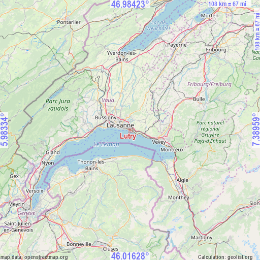
Lutry GPS coordinates[2]
46° 30' 8.676" North, 6° 41' 11.292" East
| Map corner | latitude | longitude |
|---|---|---|
| Upper-left | 46.98423°, | 5.98334° |
| Center: | 46.50241°, | 6.68647° |
| Lower-right: | 46.01628°, | 7.38959° |
| Map W x H: | 107.6×107.6 km | = 66.9×66.9mi |
| max Lat: | 47.76737° ⇑85.6% North |
| Lutry: | 46.50241° |
| min Lat: | ⇓14.4% South 45.83203° |
| min Long | Lutry | max Long |
| 5.97153° | 6.68647° | 10.44624° |
| W 7.3%⇐ | ⇒92.7% E |
Elevation
Elevation of Lutry is 386 m = 1266 ft, and this is 172.2 m = 565 ft below average elevation for this country.
| Max E: |
1845 m = 6053 ft | 92% |
| Avg. | 558.2 m = 1831 ft | |
| Lutry | 386 m = 1266 ft | |
Min E: |
197 m = 646 ft | 8% |
See also: Switzerland elevation on elevation.city.
Geographical zone
Lutry is located in North temperate zone (between Tropic of Cancer and the Arctic Circle). Distance of this North polar circle is 2230.6 km =1386 mi to North.| Distance of | km | miles | from Lutry |
|---|---|---|---|
| North Pole | 4836.5 | 3005.3 | to North |
| Arctic Circle | 2230.6 | 1386 | to North |
| Tropic Cancer | 2564.7 | 1593.6 | to South |
| Equator | 5170.6 | 3212.9 | to South |


Nearby cities:
15 places around Lutry: (largest is in red/bold)
• Belmont-sur-Lausanne
2 km =1.2 mi,  337°
337°
• Blécherette
6.4 km =4 mi,  309°
309°
• Chexbres
7.4 km =4.6 mi,  107°
107°
• Cully
3.6 km =2.2 mi, 114°
• Epalinges
5.4 km =3.4 mi, 344°
• Lausanne
4.4 km =2.7 mi,  290°
290°
• Le Mont-sur-Lausanne
7.5 km =4.7 mi,  325°
325°
• Paudex
1.4 km =0.9 mi,  283°
283°
• Prilly
7.4 km =4.6 mi,  301°
301°
• Puidoux
7.4 km =4.6 mi,  91°
91°
• Pully
2.1 km =1.3 mi, 294°
• Renens
8.6 km =5.3 mi, 298°
• Romanel-sur-Lausanne
9.2 km =5.7 mi,  317°
317°
• Saint Saphorin
9 km =5.6 mi, 111°
• Savigny
5.3 km =3.3 mi,  41°
41°
Sources, notices
• [Note1] Compared only with cities in Switzerland existing in our database
• [Src1] Map data: © OpenStreetMap contributors (CC-BY-SA)
• [Src2] Other city data from geonames.org with taken over terms of usage.
• [Src3] Geographical zone / Annual Mean Temperature by Robert A. Rohde @ Wikipedia
