Savigny geodata
Savigny (Vaud) is a populated place; located in Switzerland in Europe/Zurich (GMT+2) time zone. With population of 3,440 people, there are 511 cities with bigger population in this country. Compared to other cities in Switzerland, 84.2% of cities are located further ↑North; 92.3% of cities are located further →East and 88.9% of cities have lower elevation than Savigny. Note1


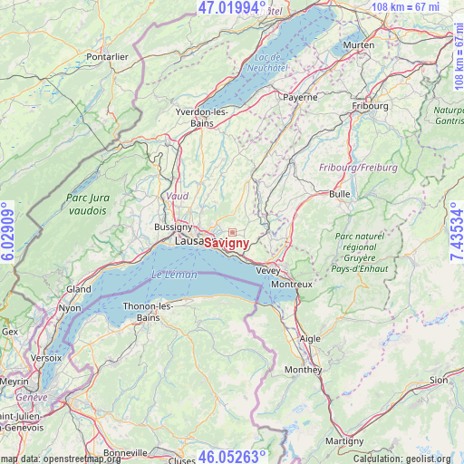
Savigny GPS coordinates[2]
46° 32' 18.384" North, 6° 43' 55.992" East
| Map corner | latitude | longitude |
|---|---|---|
| Upper-left | 47.01994°, | 6.02909° |
| Center: | 46.53844°, | 6.73222° |
| Lower-right: | 46.05263°, | 7.43534° |
| Map W x H: | 107.6×107.6 km | = 66.9×66.9mi |
| max Lat: | 47.76737° ⇑84.2% North |
| Savigny: | 46.53844° |
| min Lat: | ⇓15.8% South 45.83203° |
| min Long | Savigny | max Long |
| 5.97153° | 6.73222° | 10.44624° |
| W 7.7%⇐ | ⇒92.3% E |
Elevation
Elevation of Savigny is 799 m = 2621 ft, and this is 240.8 m = 790 ft above average elevation for this country.
| Max E: |
1845 m = 6053 ft | 11.1% |
| Savigny | 799 m 2621 ft | |
| Avg. | 558.2 m = 1831 ft | |
Min E: |
197 m = 646 ft | 88.9% |
See also: Switzerland elevation on elevation.city.
Geographical zone
Savigny is located in North temperate zone (between Tropic of Cancer and the Arctic Circle). Distance of this North polar circle is 2226.6 km =1383.5 mi to North.| Distance of | km | miles | from Savigny |
|---|---|---|---|
| North Pole | 4832.5 | 3002.8 | to North |
| Arctic Circle | 2226.6 | 1383.5 | to North |
| Tropic Cancer | 2568.7 | 1596.1 | to South |
| Equator | 5174.6 | 3215.3 | to South |


Nearby cities:
15 places around Savigny: (largest is in red/bold)
• Belmont-sur-Lausanne
4.8 km =3 mi,  243°
243°
• Chexbres
7.2 km =4.5 mi,  150°
150°
• Corcelles-le-Jorat
7.6 km =4.7 mi,  6°
6°
• Cully
5.5 km =3.4 mi,  182°
182°
• Epalinges
5 km =3.1 mi,  283°
283°
• Froideville
8 km =5 mi,  330°
330°
• Lausanne
8 km =5 mi,  251°
251°
• Le Mont-sur-Lausanne
8 km =5 mi,  285°
285°
• Lutry
5.3 km =3.3 mi,  221°
221°
• Oron-la-Ville
8 km =5 mi,  63°
63°
• Palézieux
8.2 km =5.1 mi,  87°
87°
• Paudex
6.1 km =3.8 mi,  233°
233°
• Puidoux
5.7 km =3.5 mi,  137°
137°
• Pully
6.2 km =3.9 mi, 239°
• Servion
5.1 km =3.2 mi,  44°
44°
Sources, notices
• [Note1] Compared only with cities in Switzerland existing in our database
• [Src1] Map data: © OpenStreetMap contributors (CC-BY-SA)
• [Src2] Other city data from geonames.org with taken over terms of usage.
• [Src3] Geographical zone / Annual Mean Temperature by Robert A. Rohde @ Wikipedia
