Küsnacht geodata
Küsnacht (Zurich) is a populated place; located in Switzerland in Europe/Zurich (GMT+2) time zone. With population of 11,525 people, there are 115 cities with bigger population in this country. Compared to other cities in Switzerland, 60.7% of cities are located further ↓South; 64.4% of cities are located further ←West and 77.1% of cities have higher elevation than Küsnacht. Note1


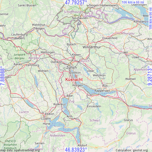
Küsnacht GPS coordinates[2]
47° 19' 4.98" North, 8° 35' 2.436" East
| Map corner | latitude | longitude |
|---|---|---|
| Upper-left | 47.79257°, | 7.88088° |
| Center: | 47.31805°, | 8.58401° |
| Lower-right: | 46.83923°, | 9.28713° |
| Map W x H: | 106×106 km | = 65.9×65.9mi |
| max Lat: | 47.76737° ⇑39.3% North |
| Küsnacht: | 47.31805° |
| min Lat: | ⇓60.7% South 45.83203° |
| min Long | Küsnacht | max Long |
| 5.97153° | 8.58401° | 10.44624° |
| W 64.4%⇐ | ⇒35.6% E |
Elevation
Elevation of Küsnacht is 427 m = 1401 ft, and this is 131.2 m = 430 ft below average elevation for this country.
| Max E: |
1845 m = 6053 ft | 77.1% |
| Avg. | 558.2 m = 1831 ft | |
| Küsnacht | 427 m = 1401 ft | |
Min E: |
197 m = 646 ft | 22.9% |
See also: Switzerland elevation on elevation.city.
Geographical zone
Küsnacht is located in North temperate zone (between Tropic of Cancer and the Arctic Circle). Distance of this North polar circle is 2139.9 km =1329.7 mi to North.| Distance of | km | miles | from Küsnacht |
|---|---|---|---|
| North Pole | 4745.8 | 2948.9 | to North |
| Arctic Circle | 2139.9 | 1329.7 | to North |
| Tropic Cancer | 2655.4 | 1650 | to South |
| Equator | 5261.3 | 3269.2 | to South |


Nearby cities:
15 places around Küsnacht: (largest is in red/bold)
• Erlenbach
2 km =1.2 mi,  148°
148°
• Erlenbach / links des Dorfbachs oberhalb Bahnlinie
2.5 km =1.6 mi, 146°
• Erlenbach / links des Dorfbachs unterhalb Bahnlinie
2.1 km =1.3 mi,  157°
157°
• Erlenbach / rechts des Dorfbachs oberhalb Bahnlinie
1.9 km =1.2 mi,  132°
132°
• Erlenbach / rechts des Dorfbachs unterhalb Bahnlinie
1.5 km =0.9 mi, 161°
• Kilchberg / Bendlikon
2.7 km =1.7 mi,  282°
282°
• Kilchberg / Schwanden
2.6 km =1.6 mi,  269°
269°
• Küsnacht / Allmend
1.1 km =0.7 mi,  109°
109°
• Küsnacht / Dorf
0.1 km =0.1 mi,  251°
251°
• Küsnacht / Goldbach
1.1 km =0.7 mi,  346°
346°
• Küsnacht / Heslibach
0.6 km =0.4 mi, 148°
• Küsnacht / Itschnach
1.6 km =1 mi,  51°
51°
• Küsnacht / Schiedhalden
0.5 km =0.3 mi, 46°
• Rüschlikon / Alte Landstrasse
2.7 km =1.7 mi,  234°
234°
• Zollikon
2.6 km =1.6 mi,  343°
343°
Sources, notices
• [Note1] Compared only with cities in Switzerland existing in our database
• [Src1] Map data: © OpenStreetMap contributors (CC-BY-SA)
• [Src2] Other city data from geonames.org with taken over terms of usage.
• [Src3] Geographical zone / Annual Mean Temperature by Robert A. Rohde @ Wikipedia
