Knonau geodata
Knonau (Zurich) is a populated place; located in Switzerland in Europe/Zurich (GMT+2) time zone. With population of 1,077 people, there are 1277 cities with bigger population in this country. Compared to other cities in Switzerland, 50.9% of cities are located further ↑North; 54.3% of cities are located further ←West and 75% of cities have higher elevation than Knonau. Note1


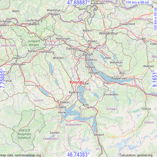
Knonau GPS coordinates[2]
47° 13' 24.6" North, 8° 27' 43.092" East
| Map corner | latitude | longitude |
|---|---|---|
| Upper-left | 47.69887°, | 7.75885° |
| Center: | 47.2235°, | 8.46197° |
| Lower-right: | 46.74383°, | 9.1651° |
| Map W x H: | 106.2×106.2 km | = 66×66mi |
| max Lat: | 47.76737° ⇑50.9% North |
| Knonau: | 47.2235° |
| min Lat: | ⇓49.1% South 45.83203° |
| min Long | Knonau | max Long |
| 5.97153° | 8.46197° | 10.44624° |
| W 54.3%⇐ | ⇒45.7% E |
Elevation
Elevation of Knonau is 431 m = 1414 ft, and this is 127.2 m = 417 ft below average elevation for this country.
| Max E: |
1845 m = 6053 ft | 75% |
| Avg. | 558.2 m = 1831 ft | |
| Knonau | 431 m = 1414 ft | |
Min E: |
197 m = 646 ft | 25% |
See also: Switzerland elevation on elevation.city.
Geographical zone
Knonau is located in North temperate zone (between Tropic of Cancer and the Arctic Circle). Distance of this North polar circle is 2150.4 km =1336.2 mi to North.| Distance of | km | miles | from Knonau |
|---|---|---|---|
| North Pole | 4756.3 | 2955.4 | to North |
| Arctic Circle | 2150.4 | 1336.2 | to North |
| Tropic Cancer | 2644.8 | 1643.4 | to South |
| Equator | 5250.8 | 3262.7 | to South |


Nearby cities:
15 places around Knonau: (largest is in red/bold)
• Aeugst / Aeugst (Dorf)
5.4 km =3.4 mi,  18°
18°
• Aeugst am Albis
5.2 km =3.2 mi, 20°
• Affoltern / Hasenbüel
5.6 km =3.5 mi,  352°
352°
• Baar
5.9 km =3.7 mi,  120°
120°
• Cham
4.6 km =2.9 mi,  178°
178°
• Hausen / Heisch
5.9 km =3.7 mi,  60°
60°
• Hausen am Albis / Hausen (Dorf)
5.9 km =3.7 mi,  66°
66°
• Mettmenstetten
2.4 km =1.5 mi,  2°
2°
• Mühlau
5.5 km =3.4 mi,  276°
276°
• Obfelden
5.5 km =3.4 mi,  325°
325°
• Obfelden / Bickwil
5.8 km =3.6 mi, 331°
• Obfelden / Oberlunnern
5.5 km =3.4 mi,  320°
320°
• Obfelden / Toussen
5.3 km =3.3 mi, 332°
• Rifferswil
3.5 km =2.2 mi,  49°
49°
• Steinhausen
3.6 km =2.2 mi,  150°
150°
Sources, notices
• [Note1] Compared only with cities in Switzerland existing in our database
• [Src1] Map data: © OpenStreetMap contributors (CC-BY-SA)
• [Src2] Other city data from geonames.org with taken over terms of usage.
• [Src3] Geographical zone / Annual Mean Temperature by Robert A. Rohde @ Wikipedia
