Baar geodata
Baar (Zug) is a populated place; located in Switzerland in Europe/Zurich (GMT+2) time zone. With population of 20,546 people, there are 40 cities with bigger population in this country. Compared to other cities in Switzerland, 53% of cities are located further ↑North; 59.6% of cities are located further ←West and 64.5% of cities have higher elevation than Baar. Note1


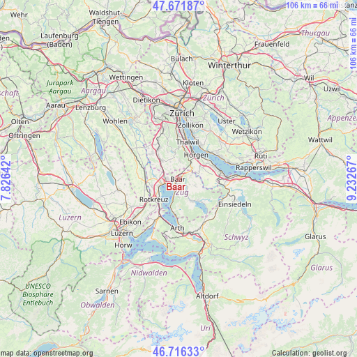
Baar GPS coordinates[2]
47° 11' 46.5" North, 8° 31' 46.344" East
| Map corner | latitude | longitude |
|---|---|---|
| Upper-left | 47.67187°, | 7.82642° |
| Center: | 47.19625°, | 8.52954° |
| Lower-right: | 46.71633°, | 9.23267° |
| Map W x H: | 106.2×106.2 km | = 66×66mi |
| max Lat: | 47.76737° ⇑53% North |
| Baar: | 47.19625° |
| min Lat: | ⇓47% South 45.83203° |
| min Long | Baar | max Long |
| 5.97153° | 8.52954° | 10.44624° |
| W 59.6%⇐ | ⇒40.4% E |
Elevation
Elevation of Baar is 447 m = 1467 ft, and this is 111.2 m = 365 ft below average elevation for this country.
| Max E: |
1845 m = 6053 ft | 64.5% |
| Avg. | 558.2 m = 1831 ft | |
| Baar | 447 m = 1467 ft | |
Min E: |
197 m = 646 ft | 35.5% |
See also: Switzerland elevation on elevation.city.
Geographical zone
Baar is located in North temperate zone (between Tropic of Cancer and the Arctic Circle). Distance of this North polar circle is 2153.4 km =1338.1 mi to North.| Distance of | km | miles | from Baar |
|---|---|---|---|
| North Pole | 4759.3 | 2957.3 | to North |
| Arctic Circle | 2153.4 | 1338.1 | to North |
| Tropic Cancer | 2641.8 | 1641.5 | to South |
| Equator | 5247.7 | 3260.8 | to South |


Nearby cities:
15 places around Baar: (largest is in red/bold)
• Aeugst am Albis
8.5 km =5.3 mi,  337°
337°
• Cham
5.2 km =3.2 mi,  252°
252°
• Hausen / Heisch
6 km =3.7 mi,  0°
0°
• Hausen am Albis / Hausen (Dorf)
5.4 km =3.4 mi, 2°
• Horgen / Allmend
8.1 km =5 mi,  45°
45°
• Horgen / Horgen (Dorfkern)
8.6 km =5.3 mi,  39°
39°
• Horgen / Oberdorf
8.3 km =5.2 mi,  33°
33°
• Hünenberg
8.2 km =5.1 mi, 253°
• Knonau
5.9 km =3.7 mi,  300°
300°
• Menzingen
5.2 km =3.2 mi,  113°
113°
• Mettmenstetten
7.4 km =4.6 mi,  317°
317°
• Rifferswil
5.8 km =3.6 mi,  334°
334°
• Steinhausen
3.3 km =2.1 mi,  267°
267°
• Unterägeri
7.9 km =4.9 mi,  147°
147°
• Zug
2.8 km =1.7 mi,  199°
199°
Sources, notices
• [Note1] Compared only with cities in Switzerland existing in our database
• [Src1] Map data: © OpenStreetMap contributors (CC-BY-SA)
• [Src2] Other city data from geonames.org with taken over terms of usage.
• [Src3] Geographical zone / Annual Mean Temperature by Robert A. Rohde @ Wikipedia
