Fehraltorf geodata
Fehraltorf (Zurich) is a populated place; located in Switzerland in Europe/Zurich (GMT+2) time zone. With population of 3,767 people, there are 471 cities with bigger population in this country. Compared to other cities in Switzerland, 70.6% of cities are located further ↓South; 78.2% of cities are located further ←West and 61.9% of cities have lower elevation than Fehraltorf. Note1


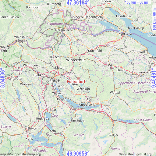
Fehraltorf GPS coordinates[2]
47° 23' 15.9" North, 8° 45' 5.364" East
| Map corner | latitude | longitude |
|---|---|---|
| Upper-left | 47.86164°, | 8.04836° |
| Center: | 47.38775°, | 8.75149° |
| Lower-right: | 46.90956°, | 9.45461° |
| Map W x H: | 105.9×105.9 km | = 65.8×65.8mi |
| max Lat: | 47.76737° ⇑29.4% North |
| Fehraltorf: | 47.38775° |
| min Lat: | ⇓70.6% South 45.83203° |
| min Long | Fehraltorf | max Long |
| 5.97153° | 8.75149° | 10.44624° |
| W 78.2%⇐ | ⇒21.8% E |
Elevation
Elevation of Fehraltorf is 531 m = 1742 ft, and this is 27.2 m = 89 ft below average elevation for this country.
| Max E: |
1845 m = 6053 ft | 38.1% |
| Avg. | 558.2 m = 1831 ft | |
| Fehraltorf | 531 m = 1742 ft | |
Min E: |
197 m = 646 ft | 61.9% |
See also: Switzerland elevation on elevation.city.
Geographical zone
Fehraltorf is located in North temperate zone (between Tropic of Cancer and the Arctic Circle). Distance of this North polar circle is 2132.2 km =1324.9 mi to North.| Distance of | km | miles | from Fehraltorf |
|---|---|---|---|
| North Pole | 4738 | 2944.1 | to North |
| Arctic Circle | 2132.2 | 1324.9 | to North |
| Tropic Cancer | 2663.1 | 1654.8 | to South |
| Equator | 5269 | 3274 | to South |


Nearby cities:
15 places around Fehraltorf: (largest is in red/bold)
• Gutenswil
2.6 km =1.6 mi,  260°
260°
• Illnau
3.5 km =2.2 mi,  319°
319°
• Illnau / Ober-Illnau
4 km =2.5 mi, 318°
• Illnau / Unter-Illnau
2.9 km =1.8 mi, 319°
• Nänikon / Nänikon (Dorfkern)
4.8 km =3 mi,  247°
247°
• Pfäffikon
4 km =2.5 mi,  130°
130°
• Pfäffikon / Irgenhausen
4.2 km =2.6 mi, 132°
• Pfäffikon / Pfäffikon (Dorfkern)
3.1 km =1.9 mi, 130°
• Russikon
2 km =1.2 mi,  60°
60°
• Uster
5.1 km =3.2 mi,  207°
207°
• Uster / Gschwader
4.2 km =2.6 mi,  222°
222°
• Uster / Ober-Uster
4.6 km =2.9 mi,  197°
197°
• Volketswil / Volketswil (Dorf)
4.6 km =2.9 mi,  273°
273°
• Weisslingen
4.9 km =3 mi,  14°
14°
• Wermatswil
2.7 km =1.7 mi, 195°
Sources, notices
• [Note1] Compared only with cities in Switzerland existing in our database
• [Src1] Map data: © OpenStreetMap contributors (CC-BY-SA)
• [Src2] Other city data from geonames.org with taken over terms of usage.
• [Src3] Geographical zone / Annual Mean Temperature by Robert A. Rohde @ Wikipedia
