Schmitten geodata
Schmitten (Fribourg) is a populated place; located in Switzerland in Europe/Zurich (GMT+2) time zone. With population of 4,040 people, there are 434 cities with bigger population in this country. Compared to other cities in Switzerland, 71.6% of cities are located further ↑North; 80.7% of cities are located further →East and 77.8% of cities have lower elevation than Schmitten. Note1


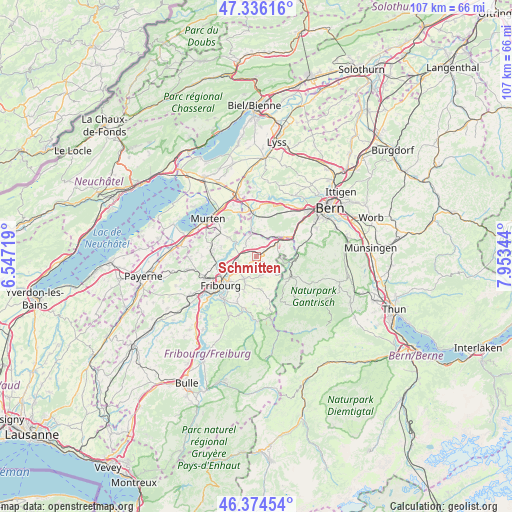
Schmitten GPS coordinates[2]
46° 51' 27" North, 7° 15' 1.116" East
| Map corner | latitude | longitude |
|---|---|---|
| Upper-left | 47.33616°, | 6.54719° |
| Center: | 46.8575°, | 7.25031° |
| Lower-right: | 46.37454°, | 7.95344° |
| Map W x H: | 106.9×106.9 km | = 66.4×66.4mi |
| max Lat: | 47.76737° ⇑71.6% North |
| Schmitten: | 46.8575° |
| min Lat: | ⇓28.4% South 45.83203° |
| min Long | Schmitten | max Long |
| 5.97153° | 7.25031° | 10.44624° |
| W 19.3%⇐ | ⇒80.7% E |
Elevation
Elevation of Schmitten is 640 m = 2100 ft, and this is 81.8 m = 268 ft above average elevation for this country.
| Max E: |
1845 m = 6053 ft | 22.2% |
| Schmitten | 640 m 2100 ft | |
| Avg. | 558.2 m = 1831 ft | |
Min E: |
197 m = 646 ft | 77.8% |
See also: Switzerland elevation on elevation.city.
Geographical zone
Schmitten is located in North temperate zone (between Tropic of Cancer and the Arctic Circle). Distance of this North polar circle is 2191.1 km =1361.5 mi to North.| Distance of | km | miles | from Schmitten |
|---|---|---|---|
| North Pole | 4797 | 2980.7 | to North |
| Arctic Circle | 2191.1 | 1361.5 | to North |
| Tropic Cancer | 2604.1 | 1618.1 | to South |
| Equator | 5210.1 | 3237.4 | to South |


Nearby cities:
15 places around Schmitten: (largest is in red/bold)
• Alterswil
6.9 km =4.3 mi,  174°
174°
• Barberêche
7 km =4.3 mi,  269°
269°
• Bösingen
4.2 km =2.6 mi,  336°
336°
• Cordast
7.7 km =4.8 mi,  285°
285°
• Düdingen
4.6 km =2.9 mi,  258°
258°
• Flamatt
6.5 km =4 mi,  56°
56°
• Fribourg
9.7 km =6 mi,  230°
230°
• Heitenried
5 km =3.1 mi,  131°
131°
• Jeuss
8.4 km =5.2 mi,  307°
307°
• Kleinbösingen
5.3 km =3.3 mi,  319°
319°
• Laupen
5 km =3.1 mi,  350°
350°
• Liebistorf
7 km =4.3 mi, 324°
• Sankt Antoni
4 km =2.5 mi, 168°
• Tafers
5.3 km =3.3 mi,  207°
207°
• Ueberstorf
4.6 km =2.9 mi,  78°
78°
Sources, notices
• [Note1] Compared only with cities in Switzerland existing in our database
• [Src1] Map data: © OpenStreetMap contributors (CC-BY-SA)
• [Src2] Other city data from geonames.org with taken over terms of usage.
• [Src3] Geographical zone / Annual Mean Temperature by Robert A. Rohde @ Wikipedia
