Eriz geodata
Eriz (Bern) is a populated place; located in Switzerland in Europe/Zurich (GMT+2) time zone. With population of 504 people, there are 1801 cities with bigger population in this country. Compared to other cities in Switzerland, 75.1% of cities are located further ↑North; 66.6% of cities are located further →East and 94.4% of cities have lower elevation than Eriz. Note1


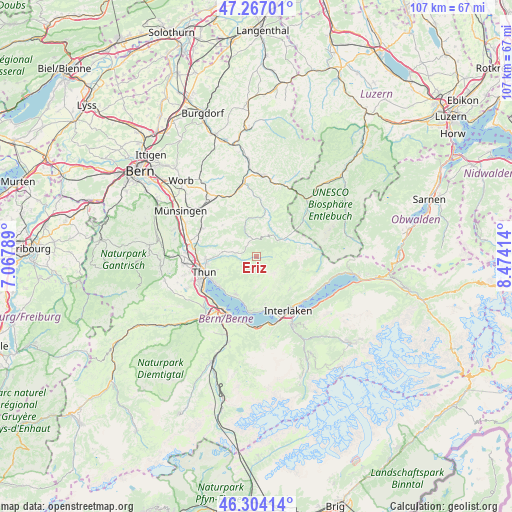
Eriz GPS coordinates[2]
46° 47' 15.828" North, 7° 46' 15.672" East
| Map corner | latitude | longitude |
|---|---|---|
| Upper-left | 47.26701°, | 7.06789° |
| Center: | 46.78773°, | 7.77102° |
| Lower-right: | 46.30414°, | 8.47414° |
| Map W x H: | 107.1×107.1 km | = 66.5×66.5mi |
| max Lat: | 47.76737° ⇑75.1% North |
| Eriz: | 46.78773° |
| min Lat: | ⇓24.9% South 45.83203° |
| min Long | Eriz | max Long |
| 5.97153° | 7.77102° | 10.44624° |
| W 33.4%⇐ | ⇒66.6% E |
Elevation
Elevation of Eriz is 984 m = 3228 ft, and this is 425.8 m = 1397 ft above average elevation for this country.
| Max E: |
1845 m = 6053 ft | 5.6% |
| Eriz | 984 m 3228 ft | |
| Avg. | 558.2 m = 1831 ft | |
Min E: |
197 m = 646 ft | 94.4% |
See also: Switzerland elevation on elevation.city.
Geographical zone
Eriz is located in North temperate zone (between Tropic of Cancer and the Arctic Circle). Distance of this North polar circle is 2198.9 km =1366.3 mi to North.| Distance of | km | miles | from Eriz |
|---|---|---|---|
| North Pole | 4804.8 | 2985.6 | to North |
| Arctic Circle | 2198.9 | 1366.3 | to North |
| Tropic Cancer | 2596.4 | 1613.3 | to South |
| Equator | 5202.3 | 3232.6 | to South |


Nearby cities:
15 places around Eriz: (largest is in red/bold)
• Beatenberg
10 km =6.2 mi,  169°
169°
• Buchholterberg
7.9 km =4.9 mi,  291°
291°
• Eggiwil
10 km =6.2 mi,  10°
10°
• Fahrni
8.9 km =5.5 mi,  274°
274°
• Habkern
9.8 km =6.1 mi,  134°
134°
• Heiligenschwendi
7.8 km =4.8 mi,  238°
238°
• Heimberg
12.7 km =7.9 mi, 273°
• Hilterfingen
10.2 km =6.3 mi,  234°
234°
• Linden
9.6 km =6 mi,  313°
313°
• Schangnau
8.1 km =5 mi,  56°
56°
• Sigriswil
9.1 km =5.7 mi,  209°
209°
• Spiez
13 km =8.1 mi, 208°
• Steffisburg
10.6 km =6.6 mi,  264°
264°
• Thun
12.1 km =7.5 mi,  250°
250°
• Unterseen
12.8 km =8 mi,  152°
152°
Sources, notices
• [Note1] Compared only with cities in Switzerland existing in our database
• [Src1] Map data: © OpenStreetMap contributors (CC-BY-SA)
• [Src2] Other city data from geonames.org with taken over terms of usage.
• [Src3] Geographical zone / Annual Mean Temperature by Robert A. Rohde @ Wikipedia
