Schangnau geodata
Schangnau (Bern) is a populated place; located in Switzerland in Europe/Zurich (GMT+2) time zone. With population of 912 people, there are 1402 cities with bigger population in this country. Compared to other cities in Switzerland, 72.9% of cities are located further ↑North; 63.8% of cities are located further →East and 93.3% of cities have lower elevation than Schangnau. Note1


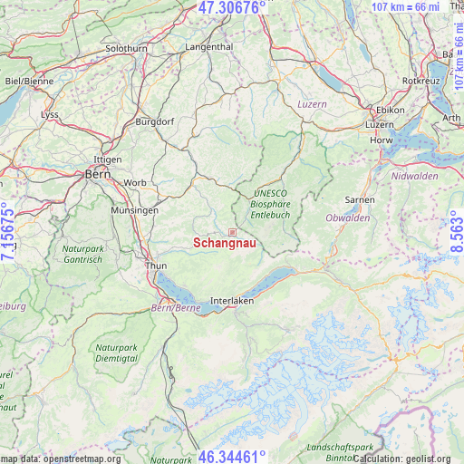
Schangnau GPS coordinates[2]
46° 49' 40.224" North, 7° 51' 35.532" East
| Map corner | latitude | longitude |
|---|---|---|
| Upper-left | 47.30676°, | 7.15675° |
| Center: | 46.82784°, | 7.85987° |
| Lower-right: | 46.34461°, | 8.563° |
| Map W x H: | 107×107 km | = 66.5×66.5mi |
| max Lat: | 47.76737° ⇑72.9% North |
| Schangnau: | 46.82784° |
| min Lat: | ⇓27.1% South 45.83203° |
| min Long | Schangnau | max Long |
| 5.97153° | 7.85987° | 10.44624° |
| W 36.2%⇐ | ⇒63.8% E |
Elevation
Elevation of Schangnau is 930 m = 3051 ft, and this is 371.8 m = 1220 ft above average elevation for this country.
| Max E: |
1845 m = 6053 ft | 6.7% |
| Schangnau | 930 m 3051 ft | |
| Avg. | 558.2 m = 1831 ft | |
Min E: |
197 m = 646 ft | 93.3% |
See also: Switzerland elevation on elevation.city.
Geographical zone
Schangnau is located in North temperate zone (between Tropic of Cancer and the Arctic Circle). Distance of this North polar circle is 2194.4 km =1363.5 mi to North.| Distance of | km | miles | from Schangnau |
|---|---|---|---|
| North Pole | 4800.3 | 2982.8 | to North |
| Arctic Circle | 2194.4 | 1363.5 | to North |
| Tropic Cancer | 2600.8 | 1616.1 | to South |
| Equator | 5206.8 | 3235.4 | to South |


Nearby cities:
15 places around Schangnau: (largest is in red/bold)
• Beatenberg
15.2 km =9.4 mi,  199°
199°
• Bowil
14.3 km =8.9 mi,  300°
300°
• Buchholterberg
14.2 km =8.8 mi,  263°
263°
• Bönigen
15.8 km =9.8 mi,  170°
170°
• Eggiwil
7.2 km =4.5 mi,  317°
317°
• Eriz
8.1 km =5 mi,  236°
236°
• Escholzmatt
11.1 km =6.9 mi,  30°
30°
• Flühli
13.4 km =8.3 mi,  62°
62°
• Habkern
11.3 km =7 mi,  178°
178°
• Langnau
13.6 km =8.5 mi,  336°
336°
• Linden
14 km =8.7 mi,  278°
278°
• Ringgenberg
14.3 km =8.9 mi, 169°
• Signau
14.5 km =9 mi,  314°
314°
• Trub
12.7 km =7.9 mi,  6°
6°
• Trubschachen
10.6 km =6.6 mi,  353°
353°
Sources, notices
• [Note1] Compared only with cities in Switzerland existing in our database
• [Src1] Map data: © OpenStreetMap contributors (CC-BY-SA)
• [Src2] Other city data from geonames.org with taken over terms of usage.
• [Src3] Geographical zone / Annual Mean Temperature by Robert A. Rohde @ Wikipedia
