Daillens geodata
Daillens (Vaud) is a populated place; located in Switzerland in Europe/Zurich (GMT+2) time zone. With population of 667 people, there are 1635 cities with bigger population in this country. Compared to other cities in Switzerland, 81.3% of cities are located further ↑North; 94.9% of cities are located further →East and 56.9% of cities have lower elevation than Daillens. Note1


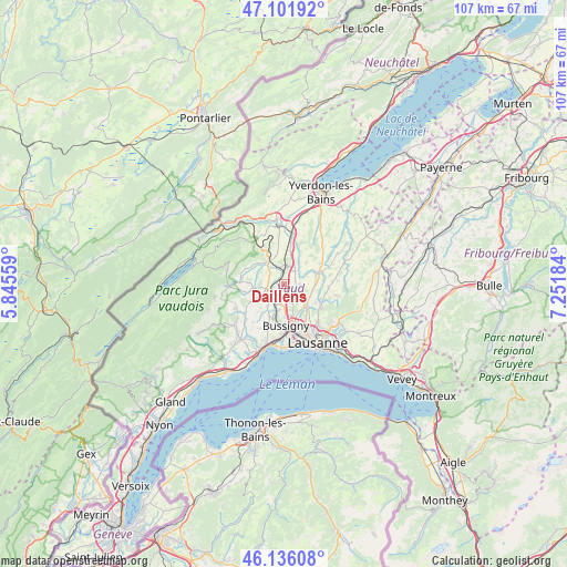
Daillens GPS coordinates[2]
46° 37' 16.14" North, 6° 32' 55.356" East
| Map corner | latitude | longitude |
|---|---|---|
| Upper-left | 47.10192°, | 5.84559° |
| Center: | 46.62115°, | 6.54871° |
| Lower-right: | 46.13608°, | 7.25184° |
| Map W x H: | 107.4×107.4 km | = 66.7×66.7mi |
| max Lat: | 47.76737° ⇑81.3% North |
| Daillens: | 46.62115° |
| min Lat: | ⇓18.7% South 45.83203° |
| min Long | Daillens | max Long |
| 5.97153° | 6.54871° | 10.44624° |
| W 5.1%⇐ | ⇒94.9% E |
Elevation
Elevation of Daillens is 504 m = 1654 ft, and this is 54.2 m = 178 ft below average elevation for this country.
| Max E: |
1845 m = 6053 ft | 43.1% |
| Avg. | 558.2 m = 1831 ft | |
| Daillens | 504 m = 1654 ft | |
Min E: |
197 m = 646 ft | 56.9% |
See also: Switzerland elevation on elevation.city.
Geographical zone
Daillens is located in North temperate zone (between Tropic of Cancer and the Arctic Circle). Distance of this North polar circle is 2217.4 km =1377.8 mi to North.| Distance of | km | miles | from Daillens |
|---|---|---|---|
| North Pole | 4823.3 | 2997.1 | to North |
| Arctic Circle | 2217.4 | 1377.8 | to North |
| Tropic Cancer | 2577.9 | 1601.8 | to South |
| Equator | 5183.8 | 3221.1 | to South |


Nearby cities:
15 places around Daillens: (largest is in red/bold)
• Assens
5.7 km =3.5 mi,  99°
99°
• Bavois
7.1 km =4.4 mi,  11°
11°
• Cheseaux
5.8 km =3.6 mi,  131°
131°
• Chevilly
6 km =3.7 mi,  293°
293°
• Cossonay
3.3 km =2.1 mi,  257°
257°
• Echallens
6.8 km =4.2 mi,  70°
70°
• Ferreyres
6.4 km =4 mi,  310°
310°
• Gollion
5 km =3.1 mi,  216°
216°
• Goumoens-la-Ville
6 km =3.7 mi,  44°
44°
• Grancy
7.2 km =4.5 mi,  243°
243°
• La Chaux
5.9 km =3.7 mi,  265°
265°
• La Sarraz
5.1 km =3.2 mi,  325°
325°
• Orny
5.4 km =3.4 mi,  341°
341°
• Penthalaz
2.1 km =1.3 mi, 237°
• Pompaples
5.9 km =3.7 mi, 329°
Sources, notices
• [Note1] Compared only with cities in Switzerland existing in our database
• [Src1] Map data: © OpenStreetMap contributors (CC-BY-SA)
• [Src2] Other city data from geonames.org with taken over terms of usage.
• [Src3] Geographical zone / Annual Mean Temperature by Robert A. Rohde @ Wikipedia
