Echallens geodata
Echallens (Vaud) is a seat of a second-order administrative division; located in Switzerland in Europe/Zurich (GMT+2) time zone. With population of 4,972 people, there are 347 cities with bigger population in this country. Compared to other cities in Switzerland, 80.8% of cities are located further ↑North; 93.4% of cities are located further →East and 75.5% of cities have lower elevation than Echallens. Note1


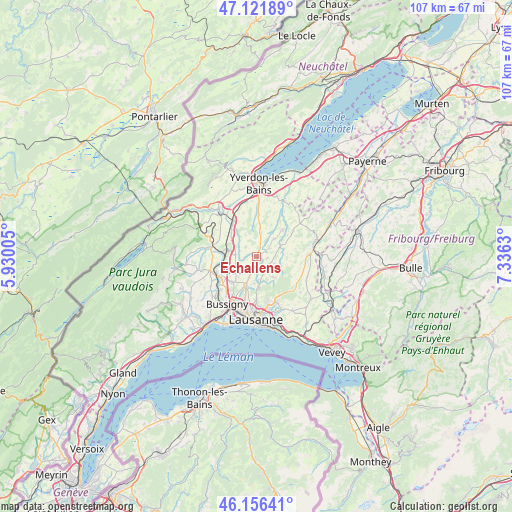
Echallens GPS coordinates[2]
46° 38' 28.68" North, 6° 37' 59.412" East
| Map corner | latitude | longitude |
|---|---|---|
| Upper-left | 47.12189°, | 5.93005° |
| Center: | 46.6413°, | 6.63317° |
| Lower-right: | 46.15641°, | 7.3363° |
| Map W x H: | 107.4×107.3 km | = 66.7×66.7mi |
| max Lat: | 47.76737° ⇑80.8% North |
| Echallens: | 46.6413° |
| min Lat: | ⇓19.2% South 45.83203° |
| min Long | Echallens | max Long |
| 5.97153° | 6.63317° | 10.44624° |
| W 6.6%⇐ | ⇒93.4% E |
Elevation
Elevation of Echallens is 622 m = 2041 ft, and this is 63.8 m = 209 ft above average elevation for this country.
| Max E: |
1845 m = 6053 ft | 24.5% |
| Echallens | 622 m 2041 ft | |
| Avg. | 558.2 m = 1831 ft | |
Min E: |
197 m = 646 ft | 75.5% |
See also: Switzerland elevation on elevation.city.
Geographical zone
Echallens is located in North temperate zone (between Tropic of Cancer and the Arctic Circle). Distance of this North polar circle is 2215.1 km =1376.4 mi to North.| Distance of | km | miles | from Echallens |
|---|---|---|---|
| North Pole | 4821 | 2995.6 | to North |
| Arctic Circle | 2215.1 | 1376.4 | to North |
| Tropic Cancer | 2580.1 | 1603.2 | to South |
| Equator | 5186 | 3222.4 | to South |


Nearby cities:
15 places around Echallens: (largest is in red/bold)
• Assens
3.3 km =2.1 mi,  195°
195°
• Bavois
6.9 km =4.3 mi,  313°
313°
• Bercher
8 km =5 mi,  45°
45°
• Bottens
3.6 km =2.2 mi,  142°
142°
• Chavornay
8.4 km =5.2 mi,  324°
324°
• Cheseaux
6.5 km =4 mi, 198°
• Daillens
6.8 km =4.2 mi,  250°
250°
• Froideville
5.8 km =3.6 mi, 140°
• Goumoens-la-Ville
3 km =1.9 mi, 311°
• Orny
8.7 km =5.4 mi,  289°
289°
• Pailly
7.4 km =4.6 mi,  25°
25°
• Penthéréaz
5 km =3.1 mi,  333°
333°
• Rueyres
7.3 km =4.5 mi,  37°
37°
• Sottens
8.4 km =5.2 mi,  79°
79°
• Vuarrens
5.1 km =3.2 mi,  12°
12°
Sources, notices
• [Note1] Compared only with cities in Switzerland existing in our database
• [Src1] Map data: © OpenStreetMap contributors (CC-BY-SA)
• [Src2] Other city data from geonames.org with taken over terms of usage.
• [Src3] Geographical zone / Annual Mean Temperature by Robert A. Rohde @ Wikipedia
