Bavois geodata
Bavois (Vaud) is a seat of a third-order administrative division; located in Switzerland in Europe/Zurich (GMT+2) time zone. With population of 662 people, there are 1640 cities with bigger population in this country. Compared to other cities in Switzerland, 79.1% of cities are located further ↑North; 94.5% of cities are located further →East and 57% of cities have higher elevation than Bavois. Note1


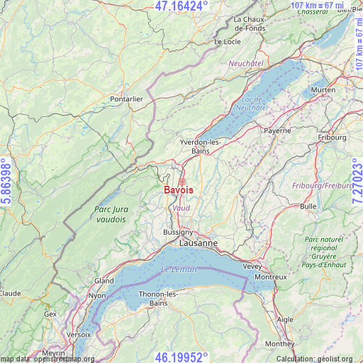
Bavois GPS coordinates[2]
46° 41' 2.508" North, 6° 34' 1.56" East
| Map corner | latitude | longitude |
|---|---|---|
| Upper-left | 47.16424°, | 5.86398° |
| Center: | 46.68403°, | 6.5671° |
| Lower-right: | 46.19952°, | 7.27023° |
| Map W x H: | 107.3×107.3 km | = 66.7×66.7mi |
| max Lat: | 47.76737° ⇑79.1% North |
| Bavois: | 46.68403° |
| min Lat: | ⇓20.9% South 45.83203° |
| min Long | Bavois | max Long |
| 5.97153° | 6.5671° | 10.44624° |
| W 5.5%⇐ | ⇒94.5% E |
Elevation
Elevation of Bavois is 462 m = 1516 ft, and this is 96.2 m = 316 ft below average elevation for this country.
| Max E: |
1845 m = 6053 ft | 57% |
| Avg. | 558.2 m = 1831 ft | |
| Bavois | 462 m = 1516 ft | |
Min E: |
197 m = 646 ft | 43% |
See also: Switzerland elevation on elevation.city.
Geographical zone
Bavois is located in North temperate zone (between Tropic of Cancer and the Arctic Circle). Distance of this North polar circle is 2210.4 km =1373.5 mi to North.| Distance of | km | miles | from Bavois |
|---|---|---|---|
| North Pole | 4816.3 | 2992.7 | to North |
| Arctic Circle | 2210.4 | 1373.5 | to North |
| Tropic Cancer | 2584.9 | 1606.2 | to South |
| Equator | 5190.8 | 3225.4 | to South |


Nearby cities:
15 places around Bavois: (largest is in red/bold)
• Assens
8.9 km =5.5 mi,  152°
152°
• Chavornay
2.1 km =1.3 mi,  4°
4°
• Chevilly
8.3 km =5.2 mi,  236°
236°
• Daillens
7.1 km =4.4 mi,  191°
191°
• Echallens
6.9 km =4.3 mi,  133°
133°
• Ferreyres
6.9 km =4.3 mi,  245°
245°
• Goumoens-la-Ville
3.9 km =2.4 mi, 134°
• La Sarraz
5.1 km =3.2 mi, 236°
• Orbe
5.3 km =3.3 mi,  328°
328°
• Orny
3.6 km =2.2 mi, 239°
• Pailly
8.5 km =5.3 mi,  76°
76°
• Penthalaz
8.8 km =5.5 mi,  201°
201°
• Penthéréaz
2.8 km =1.7 mi,  95°
95°
• Pompaples
4.8 km =3 mi, 246°
• Vuarrens
6.2 km =3.9 mi,  88°
88°
Sources, notices
• [Note1] Compared only with cities in Switzerland existing in our database
• [Src1] Map data: © OpenStreetMap contributors (CC-BY-SA)
• [Src2] Other city data from geonames.org with taken over terms of usage.
• [Src3] Geographical zone / Annual Mean Temperature by Robert A. Rohde @ Wikipedia
