Cudrefin geodata
Cudrefin (Vaud) is a populated place; located in Switzerland in Europe/Zurich (GMT+2) time zone. With population of 996 people, there are 1330 cities with bigger population in this country. Compared to other cities in Switzerland, 66.6% of cities are located further ↑North; 87.2% of cities are located further →East and 73.9% of cities have higher elevation than Cudrefin. Note1


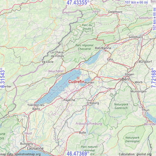
Cudrefin GPS coordinates[2]
46° 57' 20.772" North, 7° 1' 6.78" East
| Map corner | latitude | longitude |
|---|---|---|
| Upper-left | 47.43355°, | 6.31543° |
| Center: | 46.95577°, | 7.01855° |
| Lower-right: | 46.47369°, | 7.72168° |
| Map W x H: | 106.7×106.7 km | = 66.3×66.3mi |
| max Lat: | 47.76737° ⇑66.6% North |
| Cudrefin: | 46.95577° |
| min Lat: | ⇓33.4% South 45.83203° |
| min Long | Cudrefin | max Long |
| 5.97153° | 7.01855° | 10.44624° |
| W 12.8%⇐ | ⇒87.2% E |
Elevation
Elevation of Cudrefin is 433 m = 1421 ft, and this is 125.2 m = 411 ft below average elevation for this country.
| Max E: |
1845 m = 6053 ft | 73.9% |
| Avg. | 558.2 m = 1831 ft | |
| Cudrefin | 433 m = 1421 ft | |
Min E: |
197 m = 646 ft | 26.1% |
See also: Switzerland elevation on elevation.city.
Geographical zone
Cudrefin is located in North temperate zone (between Tropic of Cancer and the Arctic Circle). Distance of this North polar circle is 2180.2 km =1354.7 mi to North.| Distance of | km | miles | from Cudrefin |
|---|---|---|---|
| North Pole | 4786.1 | 2973.9 | to North |
| Arctic Circle | 2180.2 | 1354.7 | to North |
| Tropic Cancer | 2615.1 | 1624.9 | to South |
| Equator | 5221 | 3244.2 | to South |


Nearby cities:
15 places around Cudrefin: (largest is in red/bold)
• Avenches
8.6 km =5.3 mi,  168°
168°
• Bas-Vully
7.2 km =4.5 mi,  84°
84°
• Bellerive
3.6 km =2.2 mi,  175°
175°
• Cornaux
9.3 km =5.8 mi,  0°
0°
• Courgevaux
9 km =5.6 mi,  127°
127°
• Faoug
6.9 km =4.3 mi,  139°
139°
• Gals
8.5 km =5.3 mi,  17°
17°
• Gampelen
6.9 km =4.3 mi,  25°
25°
• Gletterens
9.2 km =5.7 mi,  222°
222°
• Ins
8.7 km =5.4 mi,  50°
50°
• Marin-Epagnier
6.2 km =3.9 mi,  346°
346°
• Murten/Morat
8.1 km =5 mi,  112°
112°
• Münchenwiler
9.4 km =5.8 mi,  120°
120°
• Neuchâtel
7.8 km =4.8 mi,  301°
301°
• Saint-Blaise
7 km =4.3 mi,  340°
340°
Sources, notices
• [Note1] Compared only with cities in Switzerland existing in our database
• [Src1] Map data: © OpenStreetMap contributors (CC-BY-SA)
• [Src2] Other city data from geonames.org with taken over terms of usage.
• [Src3] Geographical zone / Annual Mean Temperature by Robert A. Rohde @ Wikipedia
