Saint-Aubin-Sauges geodata
Saint-Aubin-Sauges (Neuchâtel) is a populated place; located in Switzerland in Europe/Zurich (GMT+2) time zone. With population of 2,476 people, there are 701 cities with bigger population in this country. Compared to other cities in Switzerland, 69.9% of cities are located further ↑North; 91.9% of cities are located further →East and 52% of cities have higher elevation than Saint-Aubin-Sauges. Note1


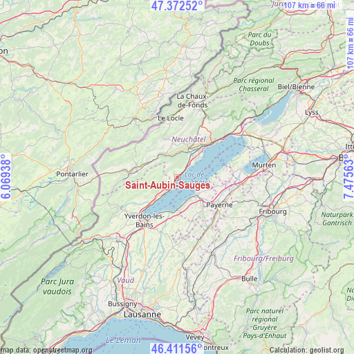
Saint-Aubin-Sauges GPS coordinates[2]
46° 53' 39.084" North, 6° 46' 21.036" East
| Map corner | latitude | longitude |
|---|---|---|
| Upper-left | 47.37252°, | 6.06938° |
| Center: | 46.89419°, | 6.77251° |
| Lower-right: | 46.41156°, | 7.47563° |
| Map W x H: | 106.8×106.8 km | = 66.4×66.4mi |
| max Lat: | 47.76737° ⇑69.9% North |
| Saint-Aubin-Sauges: | 46.89419° |
| min Lat: | ⇓30.1% South 45.83203° |
| min Long | Saint-Aubin-Sau | max Long |
| 5.97153° | 6.77251° | 10.44624° |
| W 8.1%⇐ | ⇒91.9% E |
Elevation
Elevation of Saint-Aubin-Sauges is 474 m = 1555 ft, and this is 84.2 m = 276 ft below average elevation for this country.
| Max E: |
1845 m = 6053 ft | 52% |
| Avg. | 558.2 m = 1831 ft | |
| Saint-Aubin-Sauges | 474 m = 1555 ft | |
Min E: |
197 m = 646 ft | 48% |
See also: Switzerland elevation on elevation.city.
Geographical zone
Saint-Aubin-Sauges is located in North temperate zone (between Tropic of Cancer and the Arctic Circle). Distance of this North polar circle is 2187 km =1358.9 mi to North.| Distance of | km | miles | from Saint-Aubin-Sauges |
|---|---|---|---|
| North Pole | 4792.9 | 2978.2 | to North |
| Arctic Circle | 2187 | 1358.9 | to North |
| Tropic Cancer | 2608.2 | 1620.7 | to South |
| Equator | 5214.1 | 3239.9 | to South |


Nearby cities:
15 places around Saint-Aubin-Sauges: (largest is in red/bold)
• Bevaix
5.1 km =3.2 mi,  39°
39°
• Boudry
7.9 km =4.9 mi, 38°
• Champagne
11 km =6.8 mi,  231°
231°
• Cheyres
8.9 km =5.5 mi,  172°
172°
• Concise
6.3 km =3.9 mi,  219°
219°
• Cortaillod
7.7 km =4.8 mi,  45°
45°
• Couvet
11.2 km =7 mi,  288°
288°
• Estavayer-le-Lac
7.6 km =4.7 mi,  131°
131°
• Gorgier
1 km =0.6 mi,  34°
34°
• Les Ponts-de-Martel
11.9 km =7.4 mi,  344°
344°
• Lully
8.7 km =5.4 mi,  140°
140°
• Noiraigue
7.8 km =4.8 mi,  332°
332°
• Rochefort
9.7 km =6 mi,  16°
16°
• Travers
8.9 km =5.5 mi,  304°
304°
• Yvonand
10.7 km =6.6 mi,  192°
192°
Sources, notices
• [Note1] Compared only with cities in Switzerland existing in our database
• [Src1] Map data: © OpenStreetMap contributors (CC-BY-SA)
• [Src2] Other city data from geonames.org with taken over terms of usage.
• [Src3] Geographical zone / Annual Mean Temperature by Robert A. Rohde @ Wikipedia
