Bütschwil geodata
Bütschwil (Saint Gallen) is a populated place; located in Switzerland in Europe/Zurich (GMT+2) time zone. With population of 3,393 people, there are 520 cities with bigger population in this country. Compared to other cities in Switzerland, 65.9% of cities are located further ↓South; 90.4% of cities are located further ←West and 75.2% of cities have lower elevation than Bütschwil. Note1
Administrative division(s):
- Level 1: Saint Gallen
- Level 2: Wahlkreis Toggenburg
- Level 3: Bütschwil-Ganterschwil


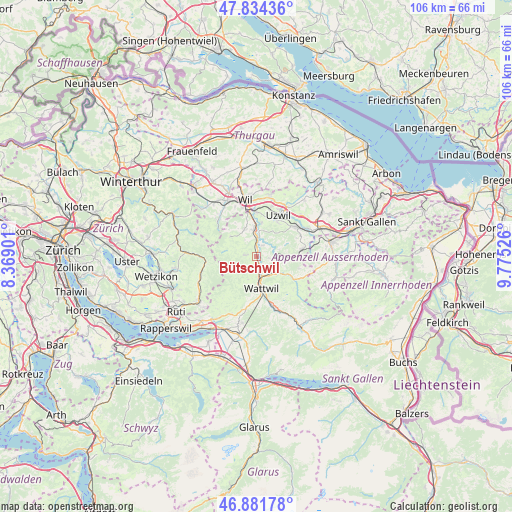
Bütschwil GPS coordinates[2]
47° 21' 36.792" North, 9° 4' 19.668" East
| Map corner | latitude | longitude |
|---|---|---|
| Upper-left | 47.83436°, | 8.36901° |
| Center: | 47.36022°, | 9.07213° |
| Lower-right: | 46.88178°, | 9.77526° |
| Map W x H: | 105.9×105.9 km | = 65.8×65.8mi |
| max Lat: | 47.76737° ⇑34.1% North |
| Bütschwil: | 47.36022° |
| min Lat: | ⇓65.9% South 45.83203° |
| min Long | Bütschwil | max Long |
| 5.97153° | 9.07213° | 10.44624° |
| W 90.4%⇐ | ⇒9.6% E |
Elevation
Elevation of Bütschwil is 619 m = 2031 ft, and this is 60.8 m = 199 ft above average elevation for this country.
| Max E: |
1845 m = 6053 ft | 24.8% |
| Bütschwil | 619 m 2031 ft | |
| Avg. | 558.2 m = 1831 ft | |
Min E: |
197 m = 646 ft | 75.2% |
See also: Switzerland elevation on elevation.city.
Geographical zone
Bütschwil is located in North temperate zone (between Tropic of Cancer and the Arctic Circle). Distance of this North polar circle is 2135.2 km =1326.8 mi to North.| Distance of | km | miles | from Bütschwil |
|---|---|---|---|
| North Pole | 4741.1 | 2946 | to North |
| Arctic Circle | 2135.2 | 1326.8 | to North |
| Tropic Cancer | 2660 | 1652.8 | to South |
| Equator | 5266 | 3272.1 | to South |


Nearby cities:
15 places around Bütschwil: (largest is in red/bold)
• Brunnadern
5.1 km =3.2 mi,  121°
121°
• Degersheim
9.8 km =6.1 mi,  80°
80°
• Fischingen
9.8 km =6.1 mi,  307°
307°
• Ganterschwil
2.8 km =1.7 mi,  33°
33°
• Jonschwil
7.2 km =4.5 mi,  8°
8°
• Kirchberg
6.2 km =3.9 mi,  337°
337°
• Lichtensteig
4.2 km =2.6 mi,  163°
163°
• Lütisburg
3.9 km =2.4 mi, 12°
• Mogelsberg
4.8 km =3 mi,  87°
87°
• Mosnang
2.2 km =1.4 mi,  276°
276°
• Oberhelfenschwil
2.9 km =1.8 mi,  97°
97°
• Oberuzwil
8.9 km =5.5 mi, 27°
• Sankt Peterzell
9.1 km =5.7 mi, 121°
• Uzwil
9.7 km =6 mi, 28°
• Wattwil
6.8 km =4.2 mi,  170°
170°
Sources, notices
• [Note1] Compared only with cities in Switzerland existing in our database
• [Src1] Map data: © OpenStreetMap contributors (CC-BY-SA)
• [Src2] Other city data from geonames.org with taken over terms of usage.
• [Src3] Geographical zone / Annual Mean Temperature by Robert A. Rohde @ Wikipedia
